Poster Print > Europe > Italy > Heritage Sites > Venice and its Lagoon
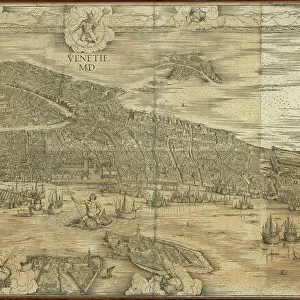
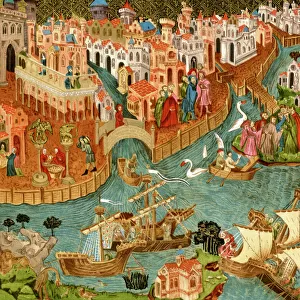
Poster Print : 16th century map of Venice

![]()
Poster Prints from Science Photo Library
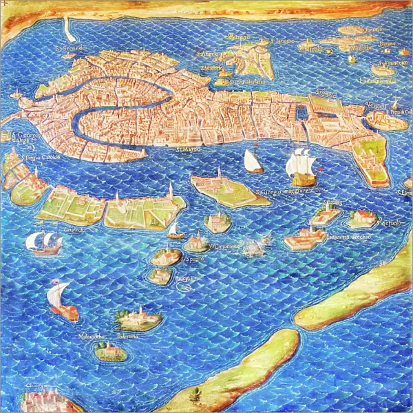
16th century map of Venice
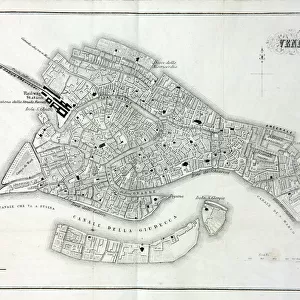
16th century map of Venice showing the lagoon. Venice is a coastal city in the north-east of Italy. The main bulk of Venice is in the upper frame of the image and the large canal at the left is the Grand Canal. The Gallery of Maps in the Vatican Museums holds maps which were commissioned between 1578 and 1580 to show the regions of Italy and territories of the church. The maps are based on the work of Ignazio Danti, a 16th century Italian priest, mathematician, astronomer and cosmographer, and are an important record of 16th century geography. Here the many islands on which Venice is built can be seen
Science Photo Library features Science and Medical images including photos and illustrations
Media ID 6350201
© SHEILA TERRY/SCIENCE PHOTO LIBRARY
1500s 16th Century Ancient Atlas Canal Cartography Coast Coastal Commemorating Commemoration Commemorative Diagram Drawing Earth Science Gallery Of Maps Ignazio Danti Islands Italian Italy Lagoon Mapping Maps Maritime Mediterranean Nautical Sciences Ship Shipping Ships Sixteenth Century Vatican Museum Vatican Museums Venice Grand Canal
27x27 inch Poster Print
Introducing the Media Storehouse collection of historic poster prints, featuring this captivating 16th century map of Venice from Science Photo Library. Witness the intricate detail of this masterpiece as it showcases the stunning Italian city during the Renaissance era. The lagoon city of Venice, famously known for its unique architecture and maritime trade, comes alive in this beautifully preserved map. Add a touch of history and culture to your space with this exquisite poster print. Perfect for home offices, libraries, or classrooms, this print is sure to inspire and intrigue. Bring the past into the present with Media Storehouse's authentic and high-quality reproductions.
Poster prints are budget friendly enlarged prints in standard poster paper sizes. Printed on 150 gsm Matte Paper for a natural feel and supplied rolled in a tube. Great for framing and should last many years. To clean wipe with a microfiber, non-abrasive cloth or napkin. Our Archival Quality Photo Prints and Fine Art Paper Prints are printed on higher quality paper and the choice of which largely depends on your budget.
Poster prints are budget friendly enlarged prints in standard poster paper sizes (A0, A1, A2, A3 etc). Whilst poster paper is sometimes thinner and less durable than our other paper types, they are still ok for framing and should last many years. Our Archival Quality Photo Prints and Fine Art Paper Prints are printed on higher quality paper and the choice of which largely depends on your budget.
Estimated Product Size is 69.2cm x 69.2cm (27.2" x 27.2")
These are individually made so all sizes are approximate
Artwork printed orientated as per the preview above, with landscape (horizontal) or portrait (vertical) orientation to match the source image.
FEATURES IN THESE COLLECTIONS
> Arts
> Artists
> O
> Oceanic Oceanic
> Europe
> Italy
> Heritage Sites
> Venice and its Lagoon
> Europe
> Italy
> Veneto
> Venice
> Europe
> Vatican City
> Maps
> Maps and Charts
> Early Maps
> Maps and Charts
> Italy
> Maps and Charts
> Related Images
> Popular Themes
> North Island
EDITORS COMMENTS
This print showcases a remarkable 16th century map of Venice, providing a glimpse into the city's rich history and geographical layout. As one of Italy's coastal gems, Venice is beautifully depicted in the upper frame of the image, with its intricate network of islands forming an enchanting labyrinth. The Grand Canal, prominently featured on the left side, serves as a majestic waterway that has witnessed centuries of bustling maritime activity. Commissioned between 1578 and 1580 for the Vatican Museums' Gallery of Maps, these maps were meticulously crafted by Ignazio Danti – an accomplished Italian priest, mathematician, astronomer, and cosmographer. Serving as invaluable records of 16th century geography, they offer insight into how Venetians navigated their empire during this era. The artistry and attention to detail evident in this illustration make it a true commemorative masterpiece. It not only captures Venice's strategic location along the Mediterranean Sea but also highlights its significance as a naval power during that time. This historical gem provides viewers with an opportunity to delve into ancient cartography while marveling at the ingenuity behind mapping techniques from centuries past. As we gaze upon this awe-inspiring piece from Science Photo Library's collection, we are transported back in time to witness firsthand how Venice emerged as a prominent force within Europe's maritime landscape.
MADE IN THE USA
Safe Shipping with 30 Day Money Back Guarantee
FREE PERSONALISATION*
We are proud to offer a range of customisation features including Personalised Captions, Color Filters and Picture Zoom Tools
SECURE PAYMENTS
We happily accept a wide range of payment options so you can pay for the things you need in the way that is most convenient for you
* Options may vary by product and licensing agreement. Zoomed Pictures can be adjusted in the Cart.