Premium Framed Print > North America > Martinique > Maps
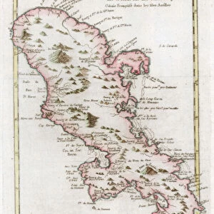
Premium Framed Print : Map Of The Isle Of Martinique Circa. 1760. From "Atlas De Toutes Les Parties Connues Du Globe Terrestre "By Cartographer Rigobert Bonne. Published Geneva Circa. 1760


![]()
Framed Photos from Design Pics
Map Of The Isle Of Martinique Circa. 1760. From "Atlas De Toutes Les Parties Connues Du Globe Terrestre "By Cartographer Rigobert Bonne. Published Geneva Circa. 1760
Map Of The Isle Of Martinique Circa. 1760. From " Atlas De Toutes Les Parties Connues Du Globe Terrestre " By Cartographer Rigobert Bonne. Published Geneva Circa. 1760
Design Pics offers Distinctively Different Imagery representing over 1,500 contributors
Media ID 18186433
© Ken Welsh / Design Pics
Cartography Geography Isle Mapmaking Plate Martinique
14"x18" Premium Frame
Contemporary style Premium Wooden Frame with 8"x12" Print. Complete with 2" White Mat and 1.25" thick MDF frame. Printed on 260 gsm premium paper. Glazed with shatter proof UV coated acrylic glass. Backing is paper covered backing with rubber bumpers. Supplied ready to hang with a pre-installed sawtooth/wire hanger. Care Instructions: Spot clean with a damp cloth. Securely packaged in a clear plastic bag and envelope in a reinforced cardboard shipper
FSC Real Wood Frame and Double Mounted with White Conservation Mountboard - Professionally Made and Ready to Hang
Estimated Image Size (if not cropped) is 20.3cm x 30.4cm (8" x 12")
Estimated Product Size is 35.6cm x 45.8cm (14" x 18")
These are individually made so all sizes are approximate
Artwork printed orientated as per the preview above, with portrait (vertical) orientation to match the source image.
FEATURES IN THESE COLLECTIONS
> Maps and Charts
> Related Images
> North America
> Martinique
> Maps
> North America
> Martinique
> Related Images
EDITORS COMMENTS
This print showcases a beautifully detailed map of the Isle of Martinique, dating back to circa 1760. Created by renowned cartographer Rigobert Bonne and published in Geneva during the same period, this map is a true testament to the artistry and precision of early mapmaking. The vibrant colors and intricate engravings bring this historical piece to life, allowing us to explore the geography and topography of Martinique as it was over two centuries ago. From its lush forests and winding rivers to its stunning coastline dotted with towns and villages, every detail has been meticulously captured on this vertical plate. As we delve into this remarkable illustration, we are transported back in time, gaining insight into how our ancestors perceived the world around them. The Isle of Martinique holds a significant place in history due to its strategic location in the Caribbean Sea, making it an important hub for trade and colonization during that era. Ken Welsh's expertly crafted print allows us to appreciate not only the artistic beauty but also the historical significance of this map. Whether you are a lover of cartography or simply intrigued by exploring different corners of our planet's past, this image will undoubtedly enrich your understanding and appreciation for both artistry and history alike.
MADE IN THE USA
Safe Shipping with 30 Day Money Back Guarantee
FREE PERSONALISATION*
We are proud to offer a range of customisation features including Personalised Captions, Color Filters and Picture Zoom Tools
SECURE PAYMENTS
We happily accept a wide range of payment options so you can pay for the things you need in the way that is most convenient for you
* Options may vary by product and licensing agreement. Zoomed Pictures can be adjusted in the Cart.