Premium Framed Print > Animals > Mammals > Muridae > Western Mouse
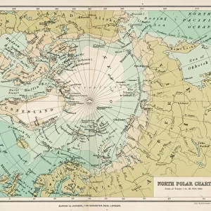
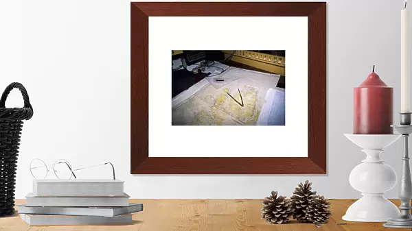
Premium Framed Print : Map of northern Spitsbergen in the Noordelichts chart room


![]()
Framed Photos from Discover Images by AWL
Map of northern Spitsbergen in the Noordelichts chart room
Discover Images by AWL is a world-leading brand of premium quality travel images
Media ID 1656689
© Will Gray
Adventure Noordelicht Norway Preparation Sail Sailing Sc Andinavian Ship Spitbergen Svalbard Voyage
14"x18" Premium Frame
Contemporary style Premium Wooden Frame with 8"x12" Print. Complete with 2" White Mat and 1.25" thick MDF frame. Printed on 260 gsm premium paper. Glazed with shatter proof UV coated acrylic glass. Backing is paper covered backing with rubber bumpers. Supplied ready to hang with a pre-installed sawtooth/wire hanger. Care Instructions: Spot clean with a damp cloth. Securely packaged in a clear plastic bag and envelope in a reinforced cardboard shipper
FSC Real Wood Frame and Double Mounted with White Conservation Mountboard - Professionally Made and Ready to Hang
Estimated Image Size (if not cropped) is 30.4cm x 20.3cm (12" x 8")
Estimated Product Size is 45.8cm x 35.6cm (18" x 14")
These are individually made so all sizes are approximate
Artwork printed orientated as per the preview above, with landscape (horizontal) orientation to match the source image.
FEATURES IN THESE COLLECTIONS
> Animals
> Mammals
> Muridae
> Western Mouse
> Europe
> Norway
> Related Images
> Europe
> Related Images
> Maps and Charts
> Related Images
> Transportation
> Ships and Boats
EDITORS COMMENTS
This print captures the essence of adventure and exploration in one frame. The image showcases a beautifully detailed map of northern Spitsbergen, proudly displayed in the Noordelichts chart room aboard a European sailing ship. As preparations for an exciting voyage are underway, this snapshot epitomizes the spirit of discovery that awaits. The map itself is a testament to the rich history and allure of Scandinavia, with Norway's majestic landscapes serving as a backdrop for this maritime expedition. Its intricate details offer a glimpse into the vastness and beauty of Svalbard, an archipelago located in Northern Europe. The Noordelicht schooner stands tall and proud, symbolizing both tradition and modernity as it embarks on its journey through these uncharted waters. This image serves as a reminder that there is still so much to explore in our world today. Whether you are an avid sailor or simply someone captivated by maps and geography, this print will transport you to another time and place. It invites you to dream about your own adventures while admiring the craftsmanship behind such navigational tools. With WG's skilled photography capturing every detail with precision, this image from Discover Images by AWL is sure to inspire wanderlust within anyone who lays eyes upon it.
MADE IN THE USA
Safe Shipping with 30 Day Money Back Guarantee
FREE PERSONALISATION*
We are proud to offer a range of customisation features including Personalised Captions, Color Filters and Picture Zoom Tools
SECURE PAYMENTS
We happily accept a wide range of payment options so you can pay for the things you need in the way that is most convenient for you
* Options may vary by product and licensing agreement. Zoomed Pictures can be adjusted in the Cart.