Premium Framed Print > Arts > Artists > N > Netherlandish School
Premium Framed Print : Map of Central America (coloured engraving)
")
")


![]()
Framed Photos from Fine Art Finder
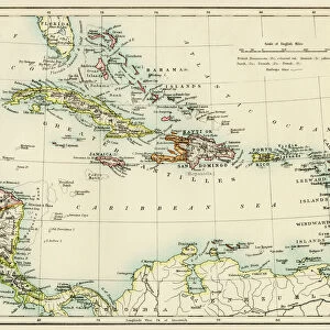
Map of Central America (coloured engraving)
VNK284159 Map of Central America (coloured engraving) by Netherlandish School, (17th century); Vorontsov Palace, Crimea, Ukraine; (add.info.: Carte de l Amerique centrale; ); eVadim Nekrasov; Netherlandish, out of copyright
Media ID 22943168
© Vadim Nekrasov / Bridgeman Images
Antilles Atlantic Ocean Caribbean Cartouche Compass Cuba Dominican Republic El Salvador Guadeloupe Gulf Of Mexico Islands Jamaica Martinique West Indies
14"x16" Premium Frame
Contemporary style Premium Wooden Frame with 8"x10" Print. Complete with 2" White Mat and 1.25" thick MDF frame. Printed on 260 gsm premium paper. Glazed with shatter proof UV coated acrylic glass. Backing is paper covered backing with rubber bumpers. Supplied ready to hang with a pre-installed sawtooth/wire hanger. Care Instructions: Spot clean with a damp cloth. Securely packaged in a clear plastic bag and envelope in a reinforced cardboard shipper
FSC Real Wood Frame and Double Mounted with White Conservation Mountboard - Professionally Made and Ready to Hang
Estimated Image Size (if not cropped) is 25.4cm x 20.3cm (10" x 8")
Estimated Product Size is 40.6cm x 35.6cm (16" x 14")
These are individually made so all sizes are approximate
Artwork printed orientated as per the preview above, with landscape (horizontal) orientation to match the source image.
FEATURES IN THESE COLLECTIONS
> Fine Art Finder
> Artists
> American School
> Fine Art Finder
> Artists
> Netherlandish School
> Fine Art Finder
> Maps (celestial & Terrestrial)
> Arts
> Artists
> M
> Mexican School Mexican School
> Arts
> Artists
> N
> Netherlandish School
> Arts
> Artists
> O
> Oceanic Oceanic
> Europe
> Ukraine
> Related Images
> Historic
> Colonial America illustrations
> Colonial America
> Maps and Charts
> Related Images
EDITORS COMMENTS
This coloured engraving, titled "Map of Central America" takes us on a journey back to the 17th century. Created by an artist from the Netherlandish School, this exquisite print showcases the intricate details and artistry of cartography during that era. Displayed in the Vorontsov Palace in Crimea, Ukraine, this historical piece provides a fascinating glimpse into the past. The map encompasses various regions such as Cuba, Dominican Republic, Jamaica, and other Caribbean islands. It highlights their significance within the vast empire of West Indies and Antilles. The elaborate cartouche and compass add an elegant touch to this colonial masterpiece. As we explore further along its borders, we are drawn towards Mexico's coastal areas along the Gulf of Mexico. The inclusion of Guadeloupe, El Salvador, Martinique emphasizes their importance in maritime trade routes during that time. The attention to detail is remarkable; every coastline and shoreline is meticulously engraved with precision. This print serves as a testament to both artistic skill and geographical knowledge prevalent during the period it was created. As we admire Vadim Nekrasov's reproduction of this extraordinary artwork from Fine Art Finder collection today, let us appreciate not only its aesthetic beauty but also its historical significance in understanding our world's past exploration and colonization efforts.
MADE IN THE USA
Safe Shipping with 30 Day Money Back Guarantee
FREE PERSONALISATION*
We are proud to offer a range of customisation features including Personalised Captions, Color Filters and Picture Zoom Tools
SECURE PAYMENTS
We happily accept a wide range of payment options so you can pay for the things you need in the way that is most convenient for you
* Options may vary by product and licensing agreement. Zoomed Pictures can be adjusted in the Cart.