Premium Framed Print > Europe > France > Canton > Landes
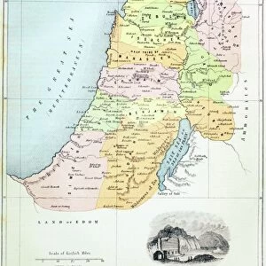
Premium Framed Print : Historical Map of the Holy Land from the 2nd crusade to the end of Christian domination (1149-1291) Engraving from Houze's "Atlas Universel" 1851 Private collection
 Engraving from Houze's 'Atlas Universel' 1851 Private collection")
 Engraving from Houze's 'Atlas Universel' 1851 Private collection")


![]()
Framed Photos from Fine Art Finder
Historical Map of the Holy Land from the 2nd crusade to the end of Christian domination (1149-1291) Engraving from Houze's "Atlas Universel" 1851 Private collection
ELD4921821 Historical Map of the Holy Land from the 2nd crusade to the end of Christian domination (1149-1291) Engraving from Houze's "Atlas Universel" 1851 Private collection; (add.info.: Historical Map of the Holy Land from the 2nd crusade to the end of Christian domination (1149-1291) Engraving from Houze's "Atlas Universel" 1851 Private collection); Photo © The Holbarn Archive
Media ID 38170146
© © The Holbarn Archive / Bridgeman Images
12 12th Xii Xiith Century 12 Century C12th Israel Israeli The 13th Century Twelfth Century Xii Century Xiith Century 12 12th 12th Xii 12th 13th Century 13 13th Xiii Xiiith Century 13 Century C13th Geographical Map Isadora Thirteenth Century Xiii Century Xiiith Century
14"x16" Premium Frame
Contemporary style Premium Wooden Frame with 8"x10" Print. Complete with 2" White Mat and 1.25" thick MDF frame. Printed on 260 gsm premium paper. Glazed with shatter proof UV coated acrylic glass. Backing is paper covered backing with rubber bumpers. Supplied ready to hang with a pre-installed sawtooth/wire hanger. Care Instructions: Spot clean with a damp cloth. Securely packaged in a clear plastic bag and envelope in a reinforced cardboard shipper
FSC Real Wood Frame and Double Mounted with White Conservation Mountboard - Professionally Made and Ready to Hang
Estimated Image Size (if not cropped) is 20.3cm x 25.4cm (8" x 10")
Estimated Product Size is 35.6cm x 40.6cm (14" x 16")
These are individually made so all sizes are approximate
Artwork printed orientated as per the preview above, with portrait (vertical) orientation to match the source image.
FEATURES IN THESE COLLECTIONS
> Fine Art Finder
> Artists
> Artist Unknown
> Asia
> Israel
> Related Images
> Europe
> France
> Canton
> Landes
> Maps and Charts
> Early Maps
EDITORS COMMENTS
This stunning historical map of the Holy Land from the 2nd crusade to the end of Christian domination (1149-1291) is a true treasure from the past. Engraved in 1851 by Houze for his "Atlas Universel," this intricate piece captures the intricate geography and history of this sacred region.
The detailed engraving showcases key locations, cities, and landmarks that played significant roles during this period of religious conflict and conquest. From Jerusalem to Bethlehem, every inch of this map tells a story of battles fought, alliances forged, and empires rising and falling.
As we gaze upon this piece from a private collection, we are transported back in time to an era filled with knights in shining armor, holy wars, and political intrigue. The vibrant colors used to bring this map to life only add to its allure and make it a truly captivating work of art.
Whether you are a history buff or simply appreciate beautiful cartography, this historical map is sure to captivate your imagination. It serves as a reminder of the complex tapestry that is the history of the Holy Land and how it continues to shape our world today.
MADE IN THE USA
Safe Shipping with 30 Day Money Back Guarantee
FREE PERSONALISATION*
We are proud to offer a range of customisation features including Personalised Captions, Color Filters and Picture Zoom Tools
SECURE PAYMENTS
We happily accept a wide range of payment options so you can pay for the things you need in the way that is most convenient for you
* Options may vary by product and licensing agreement. Zoomed Pictures can be adjusted in the Cart.