Premium Framed Print > Europe > United Kingdom > England > London > Museums > National Maritime Museum
Premium Framed Print : New map of the most flourishing kingdom of England, by Humphrey Lloyd of Denbigh, 1573 (copperplate engraving on paper)
")

")


![]()
Framed Photos from Fine Art Finder
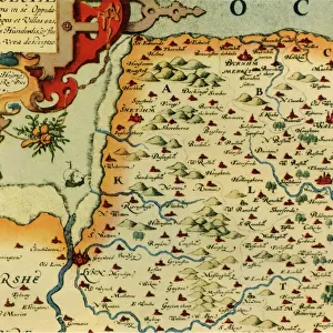
New map of the most flourishing kingdom of England, by Humphrey Lloyd of Denbigh, 1573 (copperplate engraving on paper)
7340124 New map of the most flourishing kingdom of England, by Humphrey Lloyd of Denbigh, 1573 (copperplate engraving on paper) by Ortelius, Abraham (1527-98); 42x53 cm; National Maritime Museum, London, UK; (add.info.: Creator: Abraham Ortelius; Humphrey Lloyd
Angliae Regni Florentissimi Nova Descriptio, Auctore Humfredo Lhuyd Denbygiense, an atlas sheet from an edition of Theatrum Orbis Terrarum with Latin text, published in 1573, a hand coloured copperplate engraving.
Scale approximately 1:1, 500, 000. There is a bar scale in English miles (with 60 repeated), the title is within a very elaborate strapwork cartouche, with the royal coat of arms on the central boss. Ireland is decorated with sheep and the sea area is decorated with ships and sea creatures. This map of England and Wales appears to have been the model for Christopher Saxton's atlas, published six years later.); © National Maritime Museum, Greenwich, London
Media ID 38410168
© © National Maritime Museum, Greenwich, London / Bridgeman Images
14"x16" Premium Frame
Contemporary style Premium Wooden Frame with 8"x10" Print. Complete with 2" White Mat and 1.25" thick MDF frame. Printed on 260 gsm premium paper. Glazed with shatter proof UV coated acrylic glass. Backing is paper covered backing with rubber bumpers. Supplied ready to hang with a pre-installed sawtooth/wire hanger. Care Instructions: Spot clean with a damp cloth. Securely packaged in a clear plastic bag and envelope in a reinforced cardboard shipper
FSC Real Wood Frame and Double Mounted with White Conservation Mountboard - Professionally Made and Ready to Hang
Estimated Image Size (if not cropped) is 25.4cm x 20.3cm (10" x 8")
Estimated Product Size is 40.6cm x 35.6cm (16" x 14")
These are individually made so all sizes are approximate
Artwork printed orientated as per the preview above, with landscape (horizontal) orientation to match the source image.
FEATURES IN THESE COLLECTIONS
> Fine Art Finder
> Artists
> Abraham Ortelius
> Fine Art Finder
> Artists
> Baptista Boazio
> Animals
> Mammals
> Bovidae
> Sheep
> Arts
> Artists
> O
> Abraham Ortelius
> Arts
> Artists
> S
> Christopher Saxton
> Europe
> Republic of Ireland
> Maps
> Europe
> United Kingdom
> England
> London
> Boroughs
> Greenwich
> Europe
> United Kingdom
> England
> London
> Museums
> British Museum
> Europe
> United Kingdom
> England
> London
> Museums
> Greenwich Heritage Centre
> Europe
> United Kingdom
> England
> London
> Museums
> National Maritime Museum
> Europe
> United Kingdom
> England
> London
> Royalty
> Europe
> United Kingdom
> England
> London
> Sights
> British Museum
EDITORS COMMENTS
This stunning copperplate engraving from 1573, titled "New map of the most flourishing kingdom of England" by Humphrey Lloyd of Denbigh, is a true masterpiece that captures the beauty and detail of the English landscape during this time period. Created by Abraham Ortelius, this map showcases intricate details such as a bar scale in English miles, elaborate strapwork cartouche with the royal coat of arms, and decorative elements like sheep in Ireland and sea creatures in the ocean.
The level of craftsmanship and artistry displayed in this print is truly remarkable, highlighting the skill and dedication of both Lloyd and Ortelius. The map provides a glimpse into England's rich history and geography, offering viewers a chance to explore the flourishing kingdom as it was depicted over four centuries ago.
It's fascinating to see how this map served as inspiration for future cartographers like Christopher Saxton, who would go on to create his own atlas based on similar designs. The attention to detail and precision in this engraving make it a valuable historical artifact that continues to captivate audiences today.
Displayed at the National Maritime Museum in London, this piece serves as a reminder of England's past glory and serves as a testament to the enduring legacy of cartography as an art form.
MADE IN THE USA
Safe Shipping with 30 Day Money Back Guarantee
FREE PERSONALISATION*
We are proud to offer a range of customisation features including Personalised Captions, Color Filters and Picture Zoom Tools
SECURE PAYMENTS
We happily accept a wide range of payment options so you can pay for the things you need in the way that is most convenient for you
* Options may vary by product and licensing agreement. Zoomed Pictures can be adjusted in the Cart.