Premium Framed Print > Arts > Artists > D > Cornelis I Danckerts
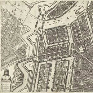
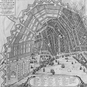
Premium Framed Print : Map of Amsterdam, 1662 (engraving) (b / w photo)
 (b / w photo)")
 (b / w photo)")


![]()
Framed Photos from Fine Art Finder
Map of Amsterdam, 1662 (engraving) (b / w photo)
XIR242868 Map of Amsterdam, 1662 (engraving) (b/w photo) by Danckerts, Cornelis I (c.1603-56); Gemeente-Archief, Amsterdam, The Netherlands; Dutch, out of copyright
Media ID 12769590
© www.bridgemanimages.com
Canal Canals Town Plan Urban Planning
14"x16" Premium Frame
Contemporary style Premium Wooden Frame with 8"x10" Print. Complete with 2" White Mat and 1.25" thick MDF frame. Printed on 260 gsm premium paper. Glazed with shatter proof UV coated acrylic glass. Backing is paper covered backing with rubber bumpers. Supplied ready to hang with a pre-installed sawtooth/wire hanger. Care Instructions: Spot clean with a damp cloth. Securely packaged in a clear plastic bag and envelope in a reinforced cardboard shipper
FSC Real Wood Frame and Double Mounted with White Conservation Mountboard - Professionally Made and Ready to Hang
Estimated Image Size (if not cropped) is 25.4cm x 20.3cm (10" x 8")
Estimated Product Size is 40.6cm x 35.6cm (16" x 14")
These are individually made so all sizes are approximate
Artwork printed orientated as per the preview above, with landscape (horizontal) orientation to match the source image.
FEATURES IN THESE COLLECTIONS
> Fine Art Finder
> Artists
> Cornelis I Danckerts
> Fine Art Finder
> Maps (celestial & Terrestrial)
> Arts
> Artists
> D
> Cornelis I Danckerts
> Arts
> Portraits
> Pop art gallery
> Street art portraits
> Europe
> Netherlands
> Amsterdam
> Europe
> Netherlands
> Maps
> Europe
> Netherlands
> Posters
> Europe
> Netherlands
> Related Images
> Maps and Charts
> Netherlands
> Maps and Charts
> Related Images
EDITORS COMMENTS
This print showcases the historic "Map of Amsterdam, 1662" engraved by Cornelis I Danckerts. The intricate details of this masterpiece come to life, offering a glimpse into the bustling cityscape of Amsterdam during the Dutch Golden Age. The map highlights the city's urban planning with its meticulously designed canals that wind their way through every corner. Each street is carefully etched, revealing a network of pathways that lead to various landmarks and districts within the city. Amsterdam's vibrant harbor takes center stage in this engraving, showcasing an array of ships docked along its shores. This bustling port was once at the heart of international trade and played a significant role in establishing Amsterdam as one of Europe's most influential cities. As you explore this remarkable piece, you can't help but be transported back in time to witness firsthand how Amsterdam looked centuries ago. It serves as a testament to the rich history and architectural beauty that still defines this enchanting city today. This photograph is sourced from Gemeente-Archief in Amsterdam, Netherlands' archives municipales and is now out of copyright. Its inclusion on Fine Art Finder allows us to appreciate and preserve these historical treasures for generations to come without any commercial use intended or mentioned here.
MADE IN THE USA
Safe Shipping with 30 Day Money Back Guarantee
FREE PERSONALISATION*
We are proud to offer a range of customisation features including Personalised Captions, Color Filters and Picture Zoom Tools
SECURE PAYMENTS
We happily accept a wide range of payment options so you can pay for the things you need in the way that is most convenient for you
* Options may vary by product and licensing agreement. Zoomed Pictures can be adjusted in the Cart.