Premium Framed Print > Fine Art Finder > Maps (celestial & Terrestrial)
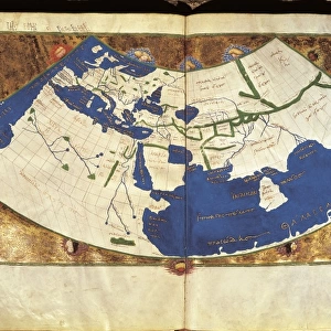
Premium Framed Print : Map of the world, Atlantis in its Decadence, published by the Theosophical


![]()
Framed Photos from Fine Art Finder
Map of the world, Atlantis in its Decadence, published by the Theosophical
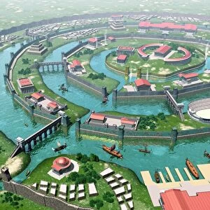
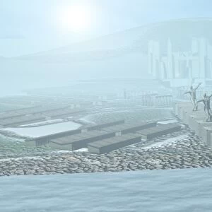
BAL54265 Map of the world, Atlantis in its Decadence, published by the Theosophical Publishing Company (litho) by English School; Private Collection; (add.info.: world after the catastrophe of 800, 000 years ago and up to the catastrophe of about 200, 000 years ago ; showing the legendary lost continent of Atlantis; ); English, out of copyright
Media ID 12918409
© www.bridgemanimages.com
14"x16" Premium Frame
Contemporary style Premium Wooden Frame with 8"x10" Print. Complete with 2" White Mat and 1.25" thick MDF frame. Printed on 260 gsm premium paper. Glazed with shatter proof UV coated acrylic glass. Backing is paper covered backing with rubber bumpers. Supplied ready to hang with a pre-installed sawtooth/wire hanger. Care Instructions: Spot clean with a damp cloth. Securely packaged in a clear plastic bag and envelope in a reinforced cardboard shipper
FSC Real Wood Frame and Double Mounted with White Conservation Mountboard - Professionally Made and Ready to Hang
Estimated Image Size (if not cropped) is 25.4cm x 20.3cm (10" x 8")
Estimated Product Size is 40.6cm x 35.6cm (16" x 14")
These are individually made so all sizes are approximate
Artwork printed orientated as per the preview above, with landscape (horizontal) orientation to match the source image.
FEATURES IN THESE COLLECTIONS
> Fine Art Finder
> Artists
> E
> English School English School
> Fine Art Finder
> Maps (celestial & Terrestrial)
EDITORS COMMENTS
This print showcases the "Map of the world, Atlantis in its Decadence" a remarkable creation published by the Theosophical Publishing Company. With intricate lithography and attention to detail, this English School masterpiece takes us on a journey through time. The map depicts a world devastated by two catastrophic events that occurred hundreds of thousands of years ago. From 800,000 years ago until approximately 200,000 years ago, our planet experienced immense turmoil and destruction. This visually stunning artwork provides an imaginative glimpse into this tumultuous period. Of particular interest is the representation of the legendary lost continent of Atlantis. Shrouded in mystery and myth, Atlantis has captivated human imagination for centuries. This map offers a unique interpretation of what this fabled land might have looked like during its decadent phase. Every corner of this print invites exploration as it reveals ancient civilizations and forgotten landscapes that once thrived before these cataclysmic events reshaped our world's geography forever. As we gaze upon this extraordinary piece from our private collection, we are reminded not only of humanity's fascination with lost civilizations but also how art can transport us to realms beyond our own reality. Let your imagination soar as you delve into the secrets hidden within this mesmerizing depiction of Earth's past.
MADE IN THE USA
Safe Shipping with 30 Day Money Back Guarantee
FREE PERSONALISATION*
We are proud to offer a range of customisation features including Personalised Captions, Color Filters and Picture Zoom Tools
SECURE PAYMENTS
We happily accept a wide range of payment options so you can pay for the things you need in the way that is most convenient for you
* Options may vary by product and licensing agreement. Zoomed Pictures can be adjusted in the Cart.