Premium Framed Print > Arts > Artists > S > Spanish School
Premium Framed Print : Claudis Ptolomaeus, 100-170


![]()
Framed Photos from Fine Art Finder
Claudis Ptolomaeus, 100-170
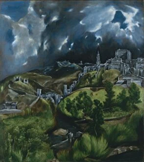
3499627 Claudis Ptolomaeus, 100-170; Biblioteca Universidad, Salamanca, Spain; (add.info.: Claudis Ptolomaeus (100-170). Cosmographia, map of The Hispanias. Manuscript of 1456. XV Century. Library of the University of Salamanca. Castile and Lion, Spain.); PHAS/UIG
Media ID 38153424
© PHAS/UIG / Bridgeman Images
Castile Cosmographia Feline Library Lions Salamanca Tawny Universities University School 1456 Educating
14"x16" Premium Frame
Contemporary style Premium Wooden Frame with 8"x10" Print. Complete with 2" White Mat and 1.25" thick MDF frame. Printed on 260 gsm premium paper. Glazed with shatter proof UV coated acrylic glass. Backing is paper covered backing with rubber bumpers. Supplied ready to hang with a pre-installed sawtooth/wire hanger. Care Instructions: Spot clean with a damp cloth. Securely packaged in a clear plastic bag and envelope in a reinforced cardboard shipper
FSC Real Wood Frame and Double Mounted with White Conservation Mountboard - Professionally Made and Ready to Hang
Estimated Image Size (if not cropped) is 25.4cm x 20.3cm (10" x 8")
Estimated Product Size is 40.6cm x 35.6cm (16" x 14")
These are individually made so all sizes are approximate
Artwork printed orientated as per the preview above, with landscape (horizontal) orientation to match the source image.
FEATURES IN THESE COLLECTIONS
> Fine Art Finder
> Artists
> El (1541-1614) Greco
> Arts
> Artists
> S
> Spanish School
> Maps and Charts
> Related Images
> Maps and Charts
> Spain
EDITORS COMMENTS
This print captures the intricate map of The Hispanias, created by the renowned Claudis Ptolomaeus in 1456. Ptolemy, as he is commonly known, was a Greek mathematician, astronomer, and geographer whose work laid the foundation for modern cartography.
The manuscript displayed in this image showcases Ptolemy's meticulous attention to detail and his advanced understanding of geography during the XV century. The map depicts the regions of Castile and Leon in Spain with remarkable accuracy for its time.
Located in the Library of the University of Salamanca, this rare manuscript is a testament to both Ptolemy's genius and the enduring legacy of educational institutions like universities. The presence of lions on either side of the map adds an element of regality and symbolism to this historical artifact.
As we gaze upon this print, we are reminded not only of Ptolemy's contributions to our understanding of the world but also of the importance of preserving knowledge through manuscripts like these. It serves as a reminder that education has always been at the heart of human progress and that libraries continue to be invaluable repositories for our collective wisdom.
MADE IN THE USA
Safe Shipping with 30 Day Money Back Guarantee
FREE PERSONALISATION*
We are proud to offer a range of customisation features including Personalised Captions, Color Filters and Picture Zoom Tools
SECURE PAYMENTS
We happily accept a wide range of payment options so you can pay for the things you need in the way that is most convenient for you
* Options may vary by product and licensing agreement. Zoomed Pictures can be adjusted in the Cart.