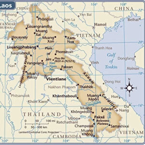
Premium Framed Print > Asia > Laos > Maps
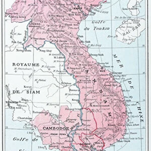
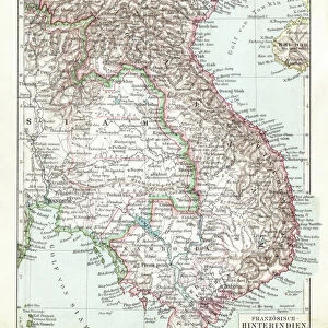
Premium Framed Print : French school textbook map of Indochina, 1905 (colour litho)
")
")


![]()
Framed Photos from Fine Art Finder
French school textbook map of Indochina, 1905 (colour litho)
CHT216702 French school textbook map of Indochina, 1905 (colour litho) by French School, (20th century); Private Collection; eArchives Charmet; French, out of copyright
Media ID 23353970
© Archives Charmet / Bridgeman Images
Annam Cochinchine Colonies French Empire Indochine Laos Siam Tonkin Tonking Vietnam Cambodge
14"x18" Premium Frame
Contemporary style Premium Wooden Frame with 8"x12" Print. Complete with 2" White Mat and 1.25" thick MDF frame. Printed on 260 gsm premium paper. Glazed with shatter proof UV coated acrylic glass. Backing is paper covered backing with rubber bumpers. Supplied ready to hang with a pre-installed sawtooth/wire hanger. Care Instructions: Spot clean with a damp cloth. Securely packaged in a clear plastic bag and envelope in a reinforced cardboard shipper
FSC Real Wood Frame and Double Mounted with White Conservation Mountboard - Professionally Made and Ready to Hang
Estimated Image Size (if not cropped) is 20.3cm x 30.4cm (8" x 12")
Estimated Product Size is 35.6cm x 45.8cm (14" x 18")
These are individually made so all sizes are approximate
Artwork printed orientated as per the preview above, with portrait (vertical) orientation to match the source image.
FEATURES IN THESE COLLECTIONS
> Fine Art Finder
> Artists
> French School
> Fine Art Finder
> Maps (celestial & Terrestrial)
> Asia
> Laos
> Related Images
> Asia
> Thailand
> Related Images
> Asia
> Turkmenistan
> Maps
> Asia
> Vietnam
> Related Images
EDITORS COMMENTS
This print showcases a French school textbook map of Indochina from 1905. The vibrant colours and intricate details bring to life the colonial era in this region. Created by an anonymous French School artist, this map offers a fascinating glimpse into the past. Indochina, known as Indo Chine Francaise during that time, was a significant part of the vast French empire. This map highlights various regions including Tonkin, Tonking, Cambodge (Cambodia), Annam, Laos, and Cochinchine. It serves as both an educational tool and a testament to France's colonial influence in Southeast Asia. The meticulousness with which this map was created is evident in every stroke of colour lithography. It not only provides geographical information but also reflects the political boundaries and administrative divisions of that period. As we admire this historical artifact now housed in a private collection at eArchives Charmet, it reminds us of the complex history shared between France and its former colonies. This image invites us to reflect on how borders have shifted over time and how they continue to shape our understanding of nations today. Let us appreciate this remarkable piece for its artistic value while acknowledging its significance within the context of colonialism's impact on Indochina's rich cultural heritage.
MADE IN THE USA
Safe Shipping with 30 Day Money Back Guarantee
FREE PERSONALISATION*
We are proud to offer a range of customisation features including Personalised Captions, Color Filters and Picture Zoom Tools
SECURE PAYMENTS
We happily accept a wide range of payment options so you can pay for the things you need in the way that is most convenient for you
* Options may vary by product and licensing agreement. Zoomed Pictures can be adjusted in the Cart.