Premium Framed Print > Arts > Landscape paintings > Waterfall and river artworks > Landscape paintings
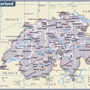
Premium Framed Print : Map of the area around the Rhine (Germany, Switzerland, France) (Engraving, 1717)
 (Engraving, 1717)")
 (Engraving, 1717)")


![]()
Framed Photos from Fine Art Finder
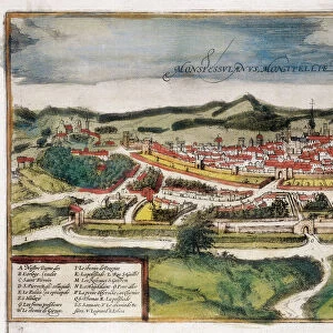
Map of the area around the Rhine (Germany, Switzerland, France) (Engraving, 1717)
LRI4712348 Map of the area around the Rhine (Germany, Switzerland, France) (Engraving, 1717) by Nolin, Jean-Baptiste (c.1657-1708); Private Collection; (add.info.: Map of Swabia and Tyrol (Germany) and Switzerland, with Lorraine and Franche Comte (France), with a detail of the landscape at the sources of the Rhine - Engraving from the atlas le theatre du monde, 1717, by Jean Baptiste Nolin (1686-1762) - Map of the area around the Rhine (Germany, Switzerland, France) - From " Le Theatre du Monde" 1717 Jean-Baptiste Nolin); Luisa Ricciarini; French, out of copyright
Media ID 23329262
© Luisa Ricciarini / Bridgeman Images
Atlas Book Franche Comt And Xe9 Franche Comte Lorraine Geographical Map
14"x18" Premium Frame
Contemporary style Premium Wooden Frame with 8"x12" Print. Complete with 2" White Mat and 1.25" thick MDF frame. Printed on 260 gsm premium paper. Glazed with shatter proof UV coated acrylic glass. Backing is paper covered backing with rubber bumpers. Supplied ready to hang with a pre-installed sawtooth/wire hanger. Care Instructions: Spot clean with a damp cloth. Securely packaged in a clear plastic bag and envelope in a reinforced cardboard shipper
FSC Real Wood Frame and Double Mounted with White Conservation Mountboard - Professionally Made and Ready to Hang
Estimated Image Size (if not cropped) is 30.4cm x 20.3cm (12" x 8")
Estimated Product Size is 45.8cm x 35.6cm (18" x 14")
These are individually made so all sizes are approximate
Artwork printed orientated as per the preview above, with landscape (horizontal) orientation to match the source image.
FEATURES IN THESE COLLECTIONS
> Fine Art Finder
> Artists
> Georg and Hogenberg Franz (1535-90)
> Fine Art Finder
> Artists
> Jean-Baptiste Nolin
> Arts
> Landscape paintings
> Waterfall and river artworks
> Landscape paintings
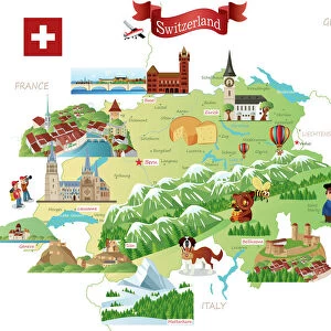
> Europe
> Germany
> River Rhine
> Europe
> Switzerland
> Maps
> Europe
> Switzerland
> Posters
> Europe
> Switzerland
> Related Images
> Europe
> Switzerland
> Rivers
EDITORS COMMENTS
This print showcases a remarkable engraving from 1717, depicting a detailed map of the area surrounding the Rhine River in Germany, Switzerland, and France. Created by Jean-Baptiste Nolin, a renowned cartographer of his time, this exquisite piece is part of a private collection. The map encompasses Swabia and Tyrol in Germany as well as Switzerland, with additional regions such as Lorraine and Franche Comte in France. It offers an intricate landscape depiction at the sources of the mighty Rhine River. This engraving was originally featured in Nolin's atlas "Le Theatre du Monde" published in 1717. Luisa Ricciarini skillfully captured this historical artwork through her lens, preserving its beauty for generations to come. The fine details on the map showcase geographical features while providing insight into the political boundaries during that era. With its rich history and artistic value, this print serves as a testament to both Nolin's mastery and Ricciarini's talent behind the camera. Its inclusion within Fine Art Finder allows art enthusiasts worldwide to appreciate not only the craftsmanship but also gain knowledge about significant geographical locations along one of Europe's most iconic rivers - the Rhine.
MADE IN THE USA
Safe Shipping with 30 Day Money Back Guarantee
FREE PERSONALISATION*
We are proud to offer a range of customisation features including Personalised Captions, Color Filters and Picture Zoom Tools
SECURE PAYMENTS
We happily accept a wide range of payment options so you can pay for the things you need in the way that is most convenient for you
* Options may vary by product and licensing agreement. Zoomed Pictures can be adjusted in the Cart.