Premium Framed Print > Aerial Photography > France
Premium Framed Print : Map of the Siege of St Sebastian, published by William Blackwood and Sons


![]()
Framed Photos from Fine Art Finder
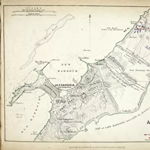
Map of the Siege of St Sebastian, published by William Blackwood and Sons
746885 Map of the Siege of St Sebastian, published by William Blackwood and Sons, Edinburgh & London, 1848 (hand-coloured engraving) by Johnston, Alexander Keith (1804-71); Private Collection; (add.info.: Siege of San SebastiAan (7 July-8 September 1813)); The Stapleton Collection; Scottish, out of copyright
Media ID 23168498
© The Stapleton Collection / Bridgeman Images
Aerial View Armies Mapping Peninsular War Portuguese Positions Wellington
14"x16" Premium Frame
Contemporary style Premium Wooden Frame with 8"x10" Print. Complete with 2" White Mat and 1.25" thick MDF frame. Printed on 260 gsm premium paper. Glazed with shatter proof UV coated acrylic glass. Backing is paper covered backing with rubber bumpers. Supplied ready to hang with a pre-installed sawtooth/wire hanger. Care Instructions: Spot clean with a damp cloth. Securely packaged in a clear plastic bag and envelope in a reinforced cardboard shipper
FSC Real Wood Frame and Double Mounted with White Conservation Mountboard - Professionally Made and Ready to Hang
Estimated Image Size (if not cropped) is 25.4cm x 20.3cm (10" x 8")
Estimated Product Size is 40.6cm x 35.6cm (16" x 14")
These are individually made so all sizes are approximate
Artwork printed orientated as per the preview above, with landscape (horizontal) orientation to match the source image.
FEATURES IN THESE COLLECTIONS
> Fine Art Finder
> Artists
> Alexander Keith Johnston
> Fine Art Finder
> Maps (celestial & Terrestrial)
> Aerial Photography
> Portugal
> Aerial Photography
> Related Images
> Aerial Photography
> Scotland
> Arts
> Artists
> A
> William Alexander
> Arts
> Artists
> K
> William Keith
> Europe
> Portugal
> Aerial Views
EDITORS COMMENTS
This hand-coloured engraving, titled "Map of the Siege of St Sebastian" takes us back to a significant moment in history. Published by William Blackwood and Sons in 1848, this print showcases the meticulous cartography skills of Alexander Keith Johnston. The map provides an aerial view of the Portuguese city during the intense Siege of San Sebastián that took place from July 7th to September 8th, 1813. As our eyes wander across this intricate artwork, we are transported to a time when armies clashed on foreign soil. The positions of both French and British forces are meticulously marked, allowing us to visualize their strategic movements during this pivotal battle in the Peninsular War. The attention to detail is remarkable; every street and building within St Sebastian is carefully outlined. This map serves not only as a historical document but also as a testament to Johnston's skillful craftsmanship. Through this print, we catch glimpses into General Wellington's military tactics as he led his troops against formidable French opposition. It offers us an opportunity to delve into the past and gain insight into one chapter of European history. Preserved within private collections today, this engraving from The Stapleton Collection reminds us that art can be more than just aesthetic pleasure—it can serve as a window into our collective pasts.
MADE IN THE USA
Safe Shipping with 30 Day Money Back Guarantee
FREE PERSONALISATION*
We are proud to offer a range of customisation features including Personalised Captions, Color Filters and Picture Zoom Tools
SECURE PAYMENTS
We happily accept a wide range of payment options so you can pay for the things you need in the way that is most convenient for you
* Options may vary by product and licensing agreement. Zoomed Pictures can be adjusted in the Cart.