Premium Framed Print > Arts > Artists > H > Joris Hoefnagel
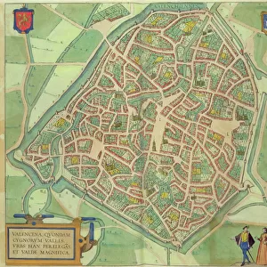
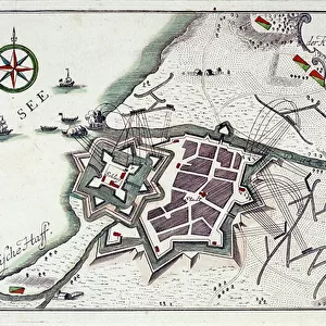
Premium Framed Print : Map of Wilnis, from Civitates Orbis Terrarum by Georg Braun (1541-1622


![]()
Framed Photos from Fine Art Finder
Map of Wilnis, from Civitates Orbis Terrarum by Georg Braun (1541-1622
STC138943 Map of Wilnis, from Civitates Orbis Terrarum by Georg Braun (1541-1622) and Frans Hogenberg (1535-90) c.1572-1617 (coloured engraving) by Hoefnagel, Joris (1542-1600) (after); Private Collection; The Stapleton Collection; Flemish, out of copyright
Media ID 23354718
© The Stapleton Collection / Bridgeman Images
Baltic Sea Cities Of The World Crest Lithuania Vilnius
14"x16" Premium Frame
Contemporary style Premium Wooden Frame with 8"x10" Print. Complete with 2" White Mat and 1.25" thick MDF frame. Printed on 260 gsm premium paper. Glazed with shatter proof UV coated acrylic glass. Backing is paper covered backing with rubber bumpers. Supplied ready to hang with a pre-installed sawtooth/wire hanger. Care Instructions: Spot clean with a damp cloth. Securely packaged in a clear plastic bag and envelope in a reinforced cardboard shipper
FSC Real Wood Frame and Double Mounted with White Conservation Mountboard - Professionally Made and Ready to Hang
Estimated Image Size (if not cropped) is 25.4cm x 20.3cm (10" x 8")
Estimated Product Size is 40.6cm x 35.6cm (16" x 14")
These are individually made so all sizes are approximate
Artwork printed orientated as per the preview above, with landscape (horizontal) orientation to match the source image.
FEATURES IN THESE COLLECTIONS
> Fine Art Finder
> Artists
> Joris (after) Hoefnagel
> Fine Art Finder
> Maps (celestial & Terrestrial)
> Animals
> Farm
> Related Images
> Arts
> Artists
> H
> Joris Hoefnagel
> Europe
> Lithuania
> Posters
> Europe
> Lithuania
> Related Images
> Europe
> Lithuania
> Vilnius
> Maps and Charts
> Related Images
> Maps and Charts
> World
EDITORS COMMENTS
This print showcases a historical gem, the "Map of Wilnis" taken from the renowned Civitates Orbis Terrarum by Georg Braun and Frans Hogenberg. Created between 1572-1617, this coloured engraving is a true testament to the artistic brilliance of Joris Hoefnagel. The map transports us back in time, offering a glimpse into the city's rich heritage and cultural significance. It depicts Wilnis as it stood centuries ago, with its charming streets and majestic buildings beautifully captured in intricate detail. The river flowing through the heart of the city adds an element of tranquility to this bustling urban landscape. Notably, one cannot overlook the presence of farm animals dotting the outskirts of Wilnis - a reminder that agriculture played a vital role in shaping this community's identity. Additionally, an elegant crest proudly adorns this map, symbolizing both unity and nobility. Beyond its local context lies an intriguing connection to distant lands; references to Lithuania and Vilnius hint at global trade routes that once connected cities across continents. This serves as a powerful reminder that even within seemingly small towns like Wilnis, there exists an interconnectedness with far-flung corners of our world. Preserved within private collections today, this remarkable piece offers us not only visual delight but also invaluable insights into our shared history. As we admire Hoefnagel's masterful engraving technique and marvel at his attention to detail, let us appreciate how art can transcend time
MADE IN THE USA
Safe Shipping with 30 Day Money Back Guarantee
FREE PERSONALISATION*
We are proud to offer a range of customisation features including Personalised Captions, Color Filters and Picture Zoom Tools
SECURE PAYMENTS
We happily accept a wide range of payment options so you can pay for the things you need in the way that is most convenient for you
* Options may vary by product and licensing agreement. Zoomed Pictures can be adjusted in the Cart.