Premium Framed Print > Arts > Artists > C > Juan de la Cosa
Premium Framed Print : Map of countries first discovered by Christopher Columbus (1451-1506) 1500 (gouache
 1500 (gouache")
 1500 (gouache")


![]()
Framed Photos from Fine Art Finder
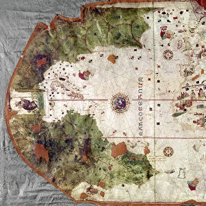
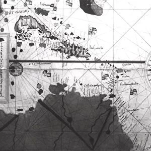
Map of countries first discovered by Christopher Columbus (1451-1506) 1500 (gouache
XIR226789 Map of countries first discovered by Christopher Columbus (1451-1506) 1500 (gouache and pen and ink on paper) (b/w photo) by Cosa, Juan de la (1460-1510); Museo Naval, Madrid, Spain; Spanish, out of copyright
Media ID 12729563
© www.bridgemanimages.com
Antilles Bahamas Caribbean Carte Christophe Colomb Cuba Iles Islands
14"x16" Premium Frame
Contemporary style Premium Wooden Frame with 8"x10" Print. Complete with 2" White Mat and 1.25" thick MDF frame. Printed on 260 gsm premium paper. Glazed with shatter proof UV coated acrylic glass. Backing is paper covered backing with rubber bumpers. Supplied ready to hang with a pre-installed sawtooth/wire hanger. Care Instructions: Spot clean with a damp cloth. Securely packaged in a clear plastic bag and envelope in a reinforced cardboard shipper
FSC Real Wood Frame and Double Mounted with White Conservation Mountboard - Professionally Made and Ready to Hang
Estimated Image Size (if not cropped) is 25.4cm x 20.3cm (10" x 8")
Estimated Product Size is 40.6cm x 35.6cm (16" x 14")
These are individually made so all sizes are approximate
Artwork printed orientated as per the preview above, with landscape (horizontal) orientation to match the source image.
FEATURES IN THESE COLLECTIONS
> Fine Art Finder
> Artists
> Juan de la Cosa
> Fine Art Finder
> Maps (celestial & Terrestrial)
> Arts
> Artists
> C
> Juan de la Cosa
> Maps and Charts
> Related Images
> Maps and Charts
> Spain
> North America
> The Bahamas
> Maps
> North America
> The Bahamas
> Related Images
> North America
> Cuba
> Maps
EDITORS COMMENTS
This print showcases a remarkable piece of history - the "Map of countries first discovered by Christopher Columbus (1451-1506) 1500". Created by Juan de la Cosa, a renowned Spanish cartographer, this gouache and pen and ink masterpiece is housed in the Museo Naval in Madrid, Spain. The map takes us back to the era when exploration was at its peak. It vividly illustrates the territories that were first encountered by Christopher Columbus during his groundbreaking voyages. From Cuba to the Caribbean, from the Bahamas to the Americas, this meticulously detailed map offers a glimpse into an age of discovery. With its black and white composition, this photograph captures every intricate line and stroke made by de la Cosa's skilled hand. The delicate balance between precision and artistry is evident as we admire each island meticulously rendered on paper. As we delve into this image, it becomes clear that it represents more than just geographical information; it symbolizes human curiosity and ambition. It reminds us of Columbus' daring spirit as he embarked on uncharted waters in search of new lands. This print serves as a testament to our collective past while also igniting our imagination for what lies beyond. It invites us to reflect on how these early explorations shaped our world today. Let us appreciate not only the beauty captured within this artwork but also ponder upon the courage required to venture into unknown territories centuries ago.
MADE IN THE USA
Safe Shipping with 30 Day Money Back Guarantee
FREE PERSONALISATION*
We are proud to offer a range of customisation features including Personalised Captions, Color Filters and Picture Zoom Tools
SECURE PAYMENTS
We happily accept a wide range of payment options so you can pay for the things you need in the way that is most convenient for you
* Options may vary by product and licensing agreement. Zoomed Pictures can be adjusted in the Cart.