Premium Framed Print > Africa > Cape Verde > Maps
Premium Framed Print : Chart of north-east Atlantic, from British Isles to Cape Verde, c.1620 (manuscript)
")
")


![]()
Framed Photos from Fine Art Finder
Chart of north-east Atlantic, from British Isles to Cape Verde, c.1620 (manuscript)
7339785 Chart of north-east Atlantic, from British Isles to Cape Verde, c.1620 (manuscript) by Unknown Artist, (17th century); 41x60 cm; National Maritime Museum, London, UK; (add.info.: Creator: unknown
This type of early vellum sea chart originated in the Mediterranean in the 13th century. They are often referred to as portulan or portolan charts, a name taken from the written sailing directions, portolani, which they supplemented and superseded, although this attribution is not always technically correct. They were drawn in coloured ink on vellum.); © National Maritime Museum, Greenwich, London
Media ID 38515846
© © National Maritime Museum, Greenwich, London / Bridgeman Images
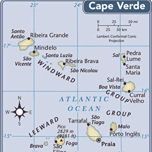
Atlantic Atlantic Ocean Cape Verde West Africa West African Western Africans
14"x18" Premium Frame
Contemporary style Premium Wooden Frame with 8"x12" Print. Complete with 2" White Mat and 1.25" thick MDF frame. Printed on 260 gsm premium paper. Glazed with shatter proof UV coated acrylic glass. Backing is paper covered backing with rubber bumpers. Supplied ready to hang with a pre-installed sawtooth/wire hanger. Care Instructions: Spot clean with a damp cloth. Securely packaged in a clear plastic bag and envelope in a reinforced cardboard shipper
FSC Real Wood Frame and Double Mounted with White Conservation Mountboard - Professionally Made and Ready to Hang
Estimated Image Size (if not cropped) is 30.4cm x 20.3cm (12" x 8")
Estimated Product Size is 45.8cm x 35.6cm (18" x 14")
These are individually made so all sizes are approximate
Artwork printed orientated as per the preview above, with landscape (horizontal) orientation to match the source image.
FEATURES IN THESE COLLECTIONS
> Fine Art Finder
> Artists
> Unknown Artist
> Africa
> Cape Verde
> Maps
> Africa
> Cape Verde
> Related Images
> Animals
> Mammals
> Muridae
> Western Mediterranean Mouse
> Arts
> Artists
> O
> Oceanic Oceanic
> Arts
> Artists
> Related Images
> Europe
> United Kingdom
> England
> London
> Boroughs
> Greenwich
> Europe
> United Kingdom
> England
> London
> Museums
> British Museum
> Europe
> United Kingdom
> England
> London
> Museums
> Greenwich Heritage Centre
> Europe
> United Kingdom
> England
> London
> Museums
> National Maritime Museum
> Europe
> United Kingdom
> England
> London
> Sights
> British Museum
EDITORS COMMENTS
This stunning print captures a rare and intricate Chart of the north-east Atlantic, from the British Isles to Cape Verde, dating back to around 1620. Created by an unknown artist in the 17th century, this manuscript is a true testament to the artistry and precision of early cartographers.
The chart is meticulously drawn on vellum in colored ink, showcasing detailed navigational routes and landmarks along the Atlantic Ocean. These types of charts, known as 'portulan' or 'portolan' charts, were essential tools for sailors during this time period, providing crucial information for safe passage across treacherous waters.
Originating in the Mediterranean in the 13th century, these sea charts revolutionized navigation with their accuracy and detail. The written sailing directions known as 'portolani' were supplemented and superseded by these visually striking maps.
As you gaze upon this historical artifact, you can't help but marvel at the skill and dedication required to create such a masterpiece. From the vibrant colors to the intricate details of coastlines and islands, every aspect of this chart tells a story of exploration and discovery in a time when mapping out uncharted territories was both thrilling and dangerous.
Displayed at the National Maritime Museum in London, UK, this Chart of north-east Atlantic serves as a reminder of our enduring fascination with maps and our relentless pursuit of knowledge about our world's oceans.
MADE IN THE USA
Safe Shipping with 30 Day Money Back Guarantee
FREE PERSONALISATION*
We are proud to offer a range of customisation features including Personalised Captions, Color Filters and Picture Zoom Tools
SECURE PAYMENTS
We happily accept a wide range of payment options so you can pay for the things you need in the way that is most convenient for you
* Options may vary by product and licensing agreement. Zoomed Pictures can be adjusted in the Cart.