Premium Framed Print > Arts > Artists > O > Abraham Ortelius
Premium Framed Print : Map of Ancient Egypt - by Abraham Ortelius, Antwerp, 1595


![]()
Framed Photos from Fine Art Finder
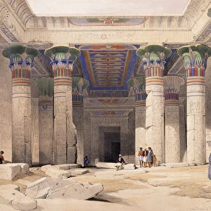
Map of Ancient Egypt - by Abraham Ortelius, Antwerp, 1595
LSE4102711 Map of Ancient Egypt - by Abraham Ortelius, Antwerp, 1595 by Ortelius, Abraham (1527-98); Private Collection; (add.info.: Map of Ancient Egypt - by Abraham Ortelius, Antwerp, 1595); Photo eLeonard de Selva; Flemish, out of copyright
Media ID 22752884
© Leonard de Selva / Bridgeman Images
14"x18" Premium Frame
Contemporary style Premium Wooden Frame with 8"x12" Print. Complete with 2" White Mat and 1.25" thick MDF frame. Printed on 260 gsm premium paper. Glazed with shatter proof UV coated acrylic glass. Backing is paper covered backing with rubber bumpers. Supplied ready to hang with a pre-installed sawtooth/wire hanger. Care Instructions: Spot clean with a damp cloth. Securely packaged in a clear plastic bag and envelope in a reinforced cardboard shipper
FSC Real Wood Frame and Double Mounted with White Conservation Mountboard - Professionally Made and Ready to Hang
Estimated Image Size (if not cropped) is 30.4cm x 20.3cm (12" x 8")
Estimated Product Size is 45.8cm x 35.6cm (18" x 14")
These are individually made so all sizes are approximate
Artwork printed orientated as per the preview above, with landscape (horizontal) orientation to match the source image.
FEATURES IN THESE COLLECTIONS
> Africa
> Egypt
> Related Images
> Arts
> Artists
> O
> Abraham Ortelius
> Maps and Charts
> Abraham Ortelius
> Maps and Charts
> Early Maps
> Maps and Charts
> Related Images
EDITORS COMMENTS
This print showcases a remarkable piece of cartographic history - the "Map of Ancient Egypt" by Abraham Ortelius, created in Antwerp in 1595. A true masterpiece, this engraving offers an intricate and detailed representation of the ancient land of Egypt. Ortelius, a renowned Flemish cartographer from the 16th century, meticulously crafted this geographical map with precision and artistry. The map provides a fascinating glimpse into the world as it was known during that era. Every inch of this print exudes historical significance. From the Nile River winding its way through lush greenery to iconic landmarks such as the Great Pyramids and Luxor Temple, each element is intricately depicted with meticulous attention to detail. As we explore this ancient landscape through Ortelius' eyes, we are transported back in time to an era filled with mystery and wonder. This print serves as both a visual delight for geography enthusiasts and a valuable resource for historians studying ancient civilizations. Preserved within a private collection, this particular photograph captures every nuance and delicate line work present on Ortelius' original creation. Thanks to Leonard de Selva's expert photography skills, viewers can appreciate every minute detail without any loss or distortion. With its rich historical context and artistic brilliance, this print truly brings alive the majesty of Ancient Egypt while honoring Ortelius' exceptional talent as one of history's greatest cartographers.
MADE IN THE USA
Safe Shipping with 30 Day Money Back Guarantee
FREE PERSONALISATION*
We are proud to offer a range of customisation features including Personalised Captions, Color Filters and Picture Zoom Tools
SECURE PAYMENTS
We happily accept a wide range of payment options so you can pay for the things you need in the way that is most convenient for you
* Options may vary by product and licensing agreement. Zoomed Pictures can be adjusted in the Cart.