Premium Framed Print > Arts > Artists > P > Portuguese School
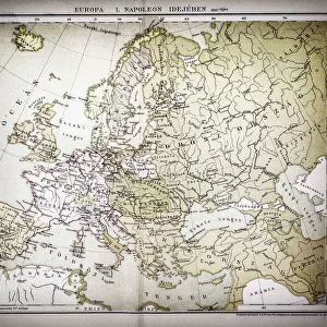
Premium Framed Print : Comic map of Europe by Frederick Rose, c. 1870 (litho)
")


")


![]()
Framed Photos from Fine Art Finder
Comic map of Europe by Frederick Rose, c. 1870 (litho)
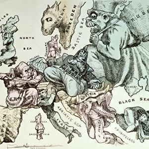
XND76008 Comic map of Europe by Frederick Rose, c.1870 (litho) by English School, (19th century); Private Collection; (add.info.: also called " Novel Carte de Europe designed for 1870" ; England enraged forgets Ireland but still keeps it in her power; Spain & Portugal smoke away lazily; France tries to overthrow Prussia who advances one hand on Holland and knee over Austria; Italy advises Bismark to keep off; Corsica & Sardinia laugh on at all; Denmark hopes to recover Holstein; Turkey is drowsily awaking from smoke; Sweden crouchng like a panther; Russia as a beggar trying for anything to fill his basket); English, out of copyright
Media ID 12936560
© www.bridgemanart.com
14"x18" Premium Frame
Contemporary style Premium Wooden Frame with 8"x12" Print. Complete with 2" White Mat and 1.25" thick MDF frame. Printed on 260 gsm premium paper. Glazed with shatter proof UV coated acrylic glass. Backing is paper covered backing with rubber bumpers. Supplied ready to hang with a pre-installed sawtooth/wire hanger. Care Instructions: Spot clean with a damp cloth. Securely packaged in a clear plastic bag and envelope in a reinforced cardboard shipper
FSC Real Wood Frame and Double Mounted with White Conservation Mountboard - Professionally Made and Ready to Hang
Estimated Image Size (if not cropped) is 30.4cm x 20.3cm (12" x 8")
Estimated Product Size is 45.8cm x 35.6cm (18" x 14")
These are individually made so all sizes are approximate
Artwork printed orientated as per the preview above, with landscape (horizontal) orientation to match the source image.
FEATURES IN THESE COLLECTIONS
> Fine Art Finder
> Schools
> English School
> Arts
> Artists
> I
> Irish School Irish School
> Arts
> Artists
> I
> Italian School Italian School
> Arts
> Artists
> P
> Portuguese School
> Arts
> Artists
> S
> Spanish School
> Asia
> Turkey
> Related Images
> Europe
> Austria
> Related Images
EDITORS COMMENTS
The "Comic map of Europe" by Frederick Rose, created around 1870, is a satirical and politically charged lithograph that offers a humorous take on the territorial ambitions and power dynamics of European nations during that time. This print, part of a private collection, showcases the wit and creativity of the English School in the 19th century. In this whimsical depiction, England takes center stage as she forgets about Ireland but still maintains control over it. Spain and Portugal lazily smoke away while France attempts to overthrow Prussia, who confidently advances towards Holland and Austria. Italy advises Bismark to stay out of their affairs while Corsica and Sardinia find amusement in it all. Denmark hopes for the recovery of Holstein, Turkey slowly awakens from its smoky haze, Sweden crouches like a panther ready to pounce, and Russia appears as a beggar desperately seeking anything to fill his basket. This comic map not only serves as an artistic representation but also reflects the political tensions prevalent during this period. It highlights each nation's aspirations through caricatured imagery with clever symbolism woven throughout. With its intricate details and playful commentary on European politics at that time, this lithograph provides viewers with both entertainment and insight into historical events.
MADE IN THE USA
Safe Shipping with 30 Day Money Back Guarantee
FREE PERSONALISATION*
We are proud to offer a range of customisation features including Personalised Captions, Color Filters and Picture Zoom Tools
SECURE PAYMENTS
We happily accept a wide range of payment options so you can pay for the things you need in the way that is most convenient for you
* Options may vary by product and licensing agreement. Zoomed Pictures can be adjusted in the Cart.