Premium Framed Print > North America > Barbados > Maps
Premium Framed Print : Map of Barbados, c.1900 (engraving)
")
")


![]()
Framed Photos from Fine Art Finder
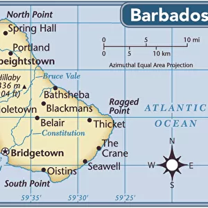
Map of Barbados, c.1900 (engraving)
533469 Map of Barbados, c.1900 (engraving); (add.info.: Map showing the parish boundaries of Barbados, circa 1902, from the 10th edition of Encyclopaedia Britannica.); Encyclopaedia Britannica/UIG
Media ID 38453958
© Encyclopaedia Britannica/UIG / Bridgeman Images
1902 19th Century Style Barbados Boundary Caribbean Caribbean Island Caribbean Sea Guidance Illustration Technique Meridian Navigational Equipment Number Old Fashioned Physical Geography The Past Western Script
14"x16" Premium Frame
Contemporary style Premium Wooden Frame with 8"x10" Print. Complete with 2" White Mat and 1.25" thick MDF frame. Printed on 260 gsm premium paper. Glazed with shatter proof UV coated acrylic glass. Backing is paper covered backing with rubber bumpers. Supplied ready to hang with a pre-installed sawtooth/wire hanger. Care Instructions: Spot clean with a damp cloth. Securely packaged in a clear plastic bag and envelope in a reinforced cardboard shipper
FSC Real Wood Frame and Double Mounted with White Conservation Mountboard - Professionally Made and Ready to Hang
Estimated Image Size (if not cropped) is 20.3cm x 25.4cm (8" x 10")
Estimated Product Size is 35.6cm x 40.6cm (14" x 16")
These are individually made so all sizes are approximate
Artwork printed orientated as per the preview above, with portrait (vertical) orientation to match the source image.
FEATURES IN THESE COLLECTIONS
> Europe
> United Kingdom
> Maps
> Europe
> United Kingdom
> Paintings
> Maps and Charts
> Related Images
> North America
> Barbados
> Maps
> North America
> Barbados
> Related Images
> Popular Themes
> North Island
EDITORS COMMENTS
This stunning vintage engraving of a Map of Barbados, circa 1900, offers a glimpse into the past with its intricate details and historical significance. The map showcases the parish boundaries of Barbados, providing a valuable insight into the geography and cartography of this Caribbean island during that time period.
The fine craftsmanship and attention to detail in this engraving reflect the artistry and precision of 19th-century cartography. Each line and boundary is meticulously drawn, capturing the essence of exploration and navigation in an era before modern technology.
As we study this map, we are transported back to a time when maps were not just tools for guidance but also works of art that told stories of discovery and adventure. The old-fashioned charm of this engraving evokes a sense of nostalgia for a bygone era when maps were essential companions for travelers seeking new horizons.
Whether you have a personal connection to Barbados or simply appreciate the beauty of antique maps, this print is sure to spark your curiosity and imagination. Let it serve as a reminder of the rich history and cultural heritage embedded in every corner of our world.
MADE IN THE USA
Safe Shipping with 30 Day Money Back Guarantee
FREE PERSONALISATION*
We are proud to offer a range of customisation features including Personalised Captions, Color Filters and Picture Zoom Tools
SECURE PAYMENTS
We happily accept a wide range of payment options so you can pay for the things you need in the way that is most convenient for you
* Options may vary by product and licensing agreement. Zoomed Pictures can be adjusted in the Cart.