Premium Framed Print > South America > Uruguay > Maps
Premium Framed Print : Map of Buenos Aires and Montevideo, c.1900 (engraving)
")
")


![]()
Framed Photos from Fine Art Finder
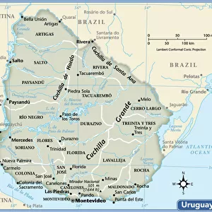
Map of Buenos Aires and Montevideo, c.1900 (engraving)
533500 Map of Buenos Aires and Montevideo, c.1900 (engraving); (add.info.: Inset map of Buenos Aires (Argentina) and Montevideo (Uruguay), circa 1902, from the 10th edition of Encyclopaedia Britannica.); Encyclopaedia Britannica/UIG
Media ID 38453962
© Encyclopaedia Britannica/UIG / Bridgeman Images
1902 19th Century Style Argentina Boundary Buenos Aires Geographical Border Guidance Illustration Technique Montevideo Navigational Equipment Old Fashioned Physical Geography Rio De La Plata River Bank The Past Uruguay Western Script
14"x18" Premium Frame
Contemporary style Premium Wooden Frame with 8"x12" Print. Complete with 2" White Mat and 1.25" thick MDF frame. Printed on 260 gsm premium paper. Glazed with shatter proof UV coated acrylic glass. Backing is paper covered backing with rubber bumpers. Supplied ready to hang with a pre-installed sawtooth/wire hanger. Care Instructions: Spot clean with a damp cloth. Securely packaged in a clear plastic bag and envelope in a reinforced cardboard shipper
FSC Real Wood Frame and Double Mounted with White Conservation Mountboard - Professionally Made and Ready to Hang
Estimated Image Size (if not cropped) is 30.4cm x 20.3cm (12" x 8")
Estimated Product Size is 45.8cm x 35.6cm (18" x 14")
These are individually made so all sizes are approximate
Artwork printed orientated as per the preview above, with landscape (horizontal) orientation to match the source image.
FEATURES IN THESE COLLECTIONS
> Fine Art Finder
> Temp Classification
> South America
> Argentina
> Buenos Aires
> South America
> Argentina
> La Plata
> South America
> Argentina
> Maps
> South America
> Argentina
> Related Images
> South America
> Uruguay
> Maps
> South America
> Uruguay
> Montevideo
> South America
> Uruguay
> Related Images
EDITORS COMMENTS
This stunning engraving from the 10th edition of Encyclopaedia Britannica showcases a detailed map of Buenos Aires and Montevideo circa 1902. The intricate lines and labels on the map provide a glimpse into the geographical landscape of these South American cities during the turn of the century.
The inset map highlights key features such as the Plata River, boundary lines, and navigational routes, offering valuable guidance for explorers and travelers alike. This vintage illustration captures a snapshot of physical geography in an old-fashioned style, reflecting the historical context of the era.
The absence of people in this image allows viewers to focus solely on the intricacies of cartography, appreciating the artistry and precision involved in creating such a detailed map. The horizontal composition adds to its visual appeal, making it suitable for display in any setting.
Whether you have a passion for history, geography, or simply appreciate fine art, this print is sure to spark curiosity and admiration. Transport yourself back in time with this depiction of Buenos Aires and Montevideo as they appeared over a century ago.
MADE IN THE USA
Safe Shipping with 30 Day Money Back Guarantee
FREE PERSONALISATION*
We are proud to offer a range of customisation features including Personalised Captions, Color Filters and Picture Zoom Tools
SECURE PAYMENTS
We happily accept a wide range of payment options so you can pay for the things you need in the way that is most convenient for you
* Options may vary by product and licensing agreement. Zoomed Pictures can be adjusted in the Cart.