Premium Framed Print > North America > United States of America > Georgia > Savannah
Premium Framed Print : Map of Georgia, c.1900 (engraving)
")
")


![]()
Framed Photos from Fine Art Finder
Map of Georgia, c.1900 (engraving)
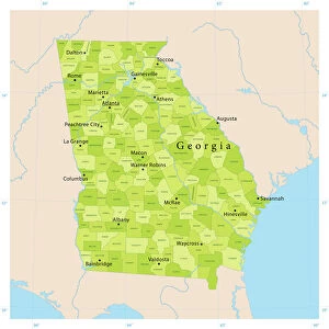
533139 Map of Georgia, c.1900 (engraving); (add.info.: Map of Georgia, United States, with inset maps of Savannah and Chickamauga National Park, circa 1902, from the 10th edition of Encyclopaedia Britannica.); Encyclopaedia Britannica/UIG
Media ID 38309818
© Encyclopaedia Britannica/UIG / Bridgeman Images
1902 19th Century Style Atlantic Ocean Boundary Geographical Border Georgia Guidance Illustration Technique National Park Navigational Equipment Old Fashioned Physical Geography Savannah State The Past Us State Border Western Script
14"x16" Premium Frame
Contemporary style Premium Wooden Frame with 8"x10" Print. Complete with 2" White Mat and 1.25" thick MDF frame. Printed on 260 gsm premium paper. Glazed with shatter proof UV coated acrylic glass. Backing is paper covered backing with rubber bumpers. Supplied ready to hang with a pre-installed sawtooth/wire hanger. Care Instructions: Spot clean with a damp cloth. Securely packaged in a clear plastic bag and envelope in a reinforced cardboard shipper
FSC Real Wood Frame and Double Mounted with White Conservation Mountboard - Professionally Made and Ready to Hang
Estimated Image Size (if not cropped) is 20.3cm x 25.4cm (8" x 10")
Estimated Product Size is 35.6cm x 40.6cm (14" x 16")
These are individually made so all sizes are approximate
Artwork printed orientated as per the preview above, with portrait (vertical) orientation to match the source image.
FEATURES IN THESE COLLECTIONS
> Fine Art Finder
> Temp Classification
> Asia
> Georgia
> Related Images
> Historic
> Historical fashion trends
> Georgian era fashion trends
> North America
> United States of America
> Georgia
> Related Images
> North America
> United States of America
> Georgia
> Savannah
> North America
> United States of America
> Maps
EDITORS COMMENTS
This stunning engraving of a Map of Georgia from around 1900 captures the intricate details and historical significance of this southern state in the United States. The map features inset maps of Savannah and Chickamauga National Park, providing a comprehensive view of the region during that time period.
The 19th-century style cartography showcases the coastline, boundaries, and geographical borders with precision and artistry. Navigational equipment symbols are scattered throughout, highlighting the importance of exploration and discovery during this era.
The inclusion of Chickamauga National Park on the map serves as a reminder of the natural beauty and historical significance found within Georgia's borders. The vertical orientation adds to its old-fashioned charm, transporting viewers back to a time when physical maps were essential tools for travelers.
As we gaze upon this detailed illustration, we can't help but marvel at how far technology has come since 1900. Yet, there is something timeless about studying maps like these - they offer us a glimpse into the past while also guiding us towards future adventures.
This print is not just a piece of artwork; it is a window into history that reminds us of Georgia's rich heritage and diverse landscapes. It is an invitation to explore and appreciate all that this beautiful state has to offer.
MADE IN THE USA
Safe Shipping with 30 Day Money Back Guarantee
FREE PERSONALISATION*
We are proud to offer a range of customisation features including Personalised Captions, Color Filters and Picture Zoom Tools
SECURE PAYMENTS
We happily accept a wide range of payment options so you can pay for the things you need in the way that is most convenient for you
* Options may vary by product and licensing agreement. Zoomed Pictures can be adjusted in the Cart.