Premium Framed Print > Asia > India > Maps
Premium Framed Print : Map of southern India with Bombay, c.1900 (engraving)
")
")


![]()
Framed Photos from Fine Art Finder
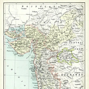
Map of southern India with Bombay, c.1900 (engraving)
533019 Map of southern India with Bombay, c.1900 (engraving); (add.info.: Map showing historical boundaries of Southern India with inset map of Bombay (now Mumbai) and the Malay Peninsula, circa 1902, from the 10th edition of Encyclopaedia Britannica.); Encyclopaedia Britannica/UIG
Media ID 38406668
© Encyclopaedia Britannica/UIG / Bridgeman Images
1902 19th Century Style Bombay Boundary City Of Bombay Geographical Border Guidance Illustration Technique Malay Peninsula Meridian Mumbai Navigational Equipment Old Fashioned Part Of Peninsula Physical Geography The Past Western Script
14"x16" Premium Frame
Contemporary style Premium Wooden Frame with 8"x10" Print. Complete with 2" White Mat and 1.25" thick MDF frame. Printed on 260 gsm premium paper. Glazed with shatter proof UV coated acrylic glass. Backing is paper covered backing with rubber bumpers. Supplied ready to hang with a pre-installed sawtooth/wire hanger. Care Instructions: Spot clean with a damp cloth. Securely packaged in a clear plastic bag and envelope in a reinforced cardboard shipper
FSC Real Wood Frame and Double Mounted with White Conservation Mountboard - Professionally Made and Ready to Hang
Estimated Image Size (if not cropped) is 25.4cm x 20.3cm (10" x 8")
Estimated Product Size is 40.6cm x 35.6cm (16" x 14")
These are individually made so all sizes are approximate
Artwork printed orientated as per the preview above, with landscape (horizontal) orientation to match the source image.
FEATURES IN THESE COLLECTIONS
> Fine Art Finder
> Temp Classification
> Asia
> India
> Related Images
> Maps and Charts
> Early Maps
> Maps and Charts
> India
> Maps and Charts
> Related Images
EDITORS COMMENTS
This engraving from c.1900 showcases a detailed map of southern India, complete with historical boundaries and an inset of Bombay (now Mumbai) and the Malay Peninsula. The intricate cartography highlights the coastline, geographical borders, and navigational elements that were crucial for exploration in the 19th century.
The Western script used on this map adds to its old-fashioned charm, transporting us back in time to an era of discovery and adventure. The inclusion of meridians and seas provides valuable guidance for travelers seeking to navigate this diverse region.
As we gaze upon this piece of history, we are reminded of the importance of maps in understanding our past and shaping our future. This illustration captures a moment frozen in time, offering a glimpse into the rich cultural heritage of India and its surrounding territories.
With no people present in the image, we are left to ponder the stories that lie within these ancient boundaries. From bustling cities like Bombay to remote corners of the peninsula, each place marked on this map holds its own unique history waiting to be explored.
Let this enchanting print serve as a reminder of how far we have come in our quest for knowledge and enlightenment.
MADE IN THE USA
Safe Shipping with 30 Day Money Back Guarantee
FREE PERSONALISATION*
We are proud to offer a range of customisation features including Personalised Captions, Color Filters and Picture Zoom Tools
SECURE PAYMENTS
We happily accept a wide range of payment options so you can pay for the things you need in the way that is most convenient for you
* Options may vary by product and licensing agreement. Zoomed Pictures can be adjusted in the Cart.