Premium Framed Print > Fine Art Storehouse > Map
Premium Framed Print : map of florence


![]()
Framed Photos from Fine Art Storehouse
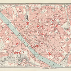
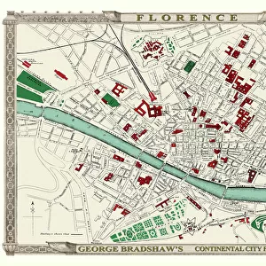
map of florence
Engraved illustrations of the City of Florence
Unleash your creativity and transform your space into a visual masterpiece!
Nastasic
Media ID 13593243
© Nikola Nastasic
60595 78279 Cartographer Chart Diagram European Culture Italian Culture Plan Planning Urban Scene World Map Drawing Art Product Image Created 19th Century Obsolete
14"x18" Premium Frame
Contemporary style Premium Wooden Frame with 8"x12" Print. Complete with 2" White Mat and 1.25" thick MDF frame. Printed on 260 gsm premium paper. Glazed with shatter proof UV coated acrylic glass. Backing is paper covered backing with rubber bumpers. Supplied ready to hang with a pre-installed sawtooth/wire hanger. Care Instructions: Spot clean with a damp cloth. Securely packaged in a clear plastic bag and envelope in a reinforced cardboard shipper
FSC Real Wood Frame and Double Mounted with White Conservation Mountboard - Professionally Made and Ready to Hang
Estimated Image Size (if not cropped) is 30.4cm x 20.3cm (12" x 8")
Estimated Product Size is 45.8cm x 35.6cm (18" x 14")
These are individually made so all sizes are approximate
Artwork printed orientated as per the preview above, with landscape (horizontal) orientation to match the source image.
FEATURES IN THESE COLLECTIONS
> Fine Art Storehouse
> The Magical World of Illustration
> Nastasic Images & Illustrations
> Fine Art Storehouse
> Map
> Historical Maps
> Fine Art Storehouse
> Map
> Italian Maps
EDITORS COMMENTS
This print showcases an exquisite "Map of Florence" from the 19th century, engraved with meticulous detail and precision. A true testament to the artistry of cartography, this image transports us back in time to a period when maps were not just tools for navigation but also works of art. The map itself is a fascinating blend of European culture, travel, and tourism. It provides a glimpse into the rich history and urban scene of Florence, Italy - a city renowned for its artistic heritage and architectural marvels. As we explore this old-world depiction, we can almost feel ourselves wandering through the narrow streets and grand piazzas that have captivated visitors for centuries. Engraved illustrations like these are now considered obsolete in our digital age, making them all the more precious as artifacts of a bygone era. The skilled cartographer behind this masterpiece has created an enduring piece that beautifully combines science and art. With its horizontal layout and intricate details, this engraving serves as both a historical document and a stunning work of art. Its presence evokes Italian culture while reminding us of how far we've come in terms of mapping technology. Whether you're an avid traveler or simply appreciate fine craftsmanship, this "Map of Florence" print by Nastasic is sure to ignite your curiosity about the world's past wonders.
MADE IN THE USA
Safe Shipping with 30 Day Money Back Guarantee
FREE PERSONALISATION*
We are proud to offer a range of customisation features including Personalised Captions, Color Filters and Picture Zoom Tools
SECURE PAYMENTS
We happily accept a wide range of payment options so you can pay for the things you need in the way that is most convenient for you
* Options may vary by product and licensing agreement. Zoomed Pictures can be adjusted in the Cart.