Premium Framed Print > Arts > Artists > O > Oceanic Oceanic
Premium Framed Print : Map of Panama 1864


![]()
Framed Photos from Fine Art Storehouse
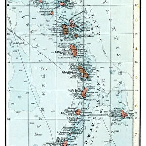
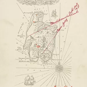
Map of Panama 1864
Map of Panama - combined with 2 different texture overlays
Unleash your creativity and transform your space into a visual masterpiece!
THEPALMER
Media ID 13613803
© Roberto A Sanchez
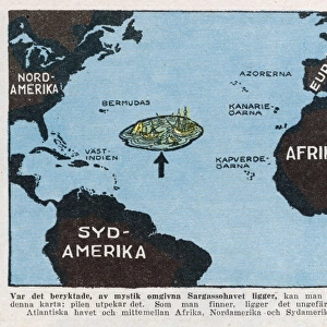
Antigua Atlantic Ocean Backgrounds Bahamas Barbados Bermuda Caribbean Sea Cayman Islands Central America Cuba Dirty Florida Florida Us State Greater Antilles Gulf Coast States Haiti Island Journey Mexico Panama Paper Patina Puerto Rico Stained Textured Effect Topography Trinidad And Tobago West Indies Antigua Leeward Islands Dominica
14"x18" Premium Frame
Contemporary style Premium Wooden Frame with 8"x12" Print. Complete with 2" White Mat and 1.25" thick MDF frame. Printed on 260 gsm premium paper. Glazed with shatter proof UV coated acrylic glass. Backing is paper covered backing with rubber bumpers. Supplied ready to hang with a pre-installed sawtooth/wire hanger. Care Instructions: Spot clean with a damp cloth. Securely packaged in a clear plastic bag and envelope in a reinforced cardboard shipper
FSC Real Wood Frame and Double Mounted with White Conservation Mountboard - Professionally Made and Ready to Hang
Estimated Image Size (if not cropped) is 30.4cm x 20.3cm (12" x 8")
Estimated Product Size is 45.8cm x 35.6cm (18" x 14")
These are individually made so all sizes are approximate
Artwork printed orientated as per the preview above, with landscape (horizontal) orientation to match the source image.
FEATURES IN THESE COLLECTIONS
> Fine Art Storehouse
> The Magical World of Illustration
> Palmer Illustrated Collection
> Fine Art Storehouse
> Map
> Historical Maps
> Arts
> Artists
> O
> Oceanic Oceanic
> Maps and Charts
> Related Images
> North America
> Antigua and Barbuda
> Maps
> North America
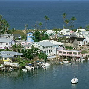
> The Bahamas
> Maps
> North America
> The Bahamas
> Related Images
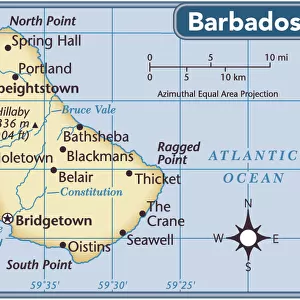
> North America
> Barbados
> Maps
> North America
> Barbados
> Related Images
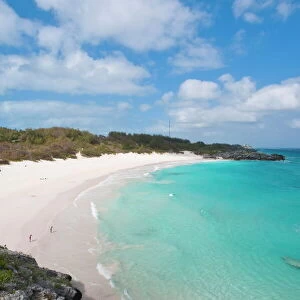
> North America
> Bermuda
> Maps
> North America
> Bermuda
> Related Images
EDITORS COMMENTS
This print by THEPALMER takes us back in time to the year 1864, showcasing a beautifully detailed "Map of Panama". The combination of two different texture overlays adds an intriguing and antique feel to this cartographic masterpiece. As we gaze upon this engraved image, we are transported into an era where travel was not as effortless as it is today. The stained and textured effect on the paper evokes a sense of history and adventure, reminding us of the journeys taken by explorers who navigated these lands centuries ago. The map encompasses various regions including Dominica, Trinidad and Tobago, Haiti, Bermuda, Puerto Rico, Cuba, Mexico, Bahamas, Antigua Barbados, Cayman Islands - all part of the Greater Antilles in the West Indies. It stretches across Central America with Panama at its heart. With intricate topography displayed alongside coastlines bordering both the Caribbean Sea and Atlantic Ocean; this piece offers a glimpse into how our world appeared during that time period. The patina acquired over years gives it character while maintaining its authenticity. This horizontal composition captures Florida's US state along with Gulf Coast states like Texas and Louisiana. THEPALMER's photography skillfully preserves this historical artifact for us to appreciate today. As we admire this remarkable artwork devoid of people but filled with rich cultural significance; we can't help but be reminded of our interconnectedness through time and space.
MADE IN THE USA
Safe Shipping with 30 Day Money Back Guarantee
FREE PERSONALISATION*
We are proud to offer a range of customisation features including Personalised Captions, Color Filters and Picture Zoom Tools
SECURE PAYMENTS
We happily accept a wide range of payment options so you can pay for the things you need in the way that is most convenient for you
* Options may vary by product and licensing agreement. Zoomed Pictures can be adjusted in the Cart.