Premium Framed Print > Arts > Artists > P > Portuguese School
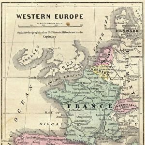
Premium Framed Print : Map of Spain and France 1869


![]()
Framed Photos from Fine Art Storehouse
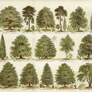
Map of Spain and France 1869
Cornells Grammars-School Geography - S.S. Cornell - New York D. Appleton and Company 1869
Unleash your creativity and transform your space into a visual masterpiece!
THEPALMER
Media ID 13668859
© Roberto A Sanchez
62990 Earth Globe Man Made Object Globe Navigational Equipment Portugal Obsolete Retro Styled
14"x16" Premium Frame
Contemporary style Premium Wooden Frame with 8"x10" Print. Complete with 2" White Mat and 1.25" thick MDF frame. Printed on 260 gsm premium paper. Glazed with shatter proof UV coated acrylic glass. Backing is paper covered backing with rubber bumpers. Supplied ready to hang with a pre-installed sawtooth/wire hanger. Care Instructions: Spot clean with a damp cloth. Securely packaged in a clear plastic bag and envelope in a reinforced cardboard shipper
FSC Real Wood Frame and Double Mounted with White Conservation Mountboard - Professionally Made and Ready to Hang
Estimated Image Size (if not cropped) is 20.3cm x 25.4cm (8" x 10")
Estimated Product Size is 35.6cm x 40.6cm (14" x 16")
These are individually made so all sizes are approximate
Artwork printed orientated as per the preview above, with portrait (vertical) orientation to match the source image.
FEATURES IN THESE COLLECTIONS
> Fine Art Storehouse
> The Magical World of Illustration
> Palmer Illustrated Collection
> Fine Art Storehouse
> Map
> Historical Maps
> Arts
> Artists
> P
> Portuguese School
> Arts
> Artists
> S
> Spanish School
> Europe
> Portugal
> Related Images
> Europe
> Related Images
> Europe
> Spain
> Related Images
EDITORS COMMENTS
This print showcases a vintage map of Spain and France from the year 1869. The intricate details and retro styling of this antique piece take us back in time to an era when cartography was meticulously engraved by hand. This particular image is sourced from "Cornells Grammars-School Geography" a renowned publication by S. S. Cornell, published in New York by D. Appleton and Company. The map itself offers a fascinating glimpse into the past, depicting the physical geography of Spain, Portugal, and France during that period. Its old-world charm evokes feelings of nostalgia as we observe the delicate engravings that bring these countries to life on paper. As we examine this engraving closely, we can appreciate how it represents not only an artistic creation but also a valuable navigational tool used at the time. The globe man-made object featured within adds another layer of intrigue to this composition. "The Map of Spain and France 1869" is more than just an obsolete relic; it serves as a testament to human curiosity about our world's landscapes throughout history. With its vertical orientation and detailed illustration, this print invites us to explore Europe's rich tapestry through both geographical knowledge and artistic appreciation. THEPALMER has skillfully captured this timeless piece with precision, allowing viewers to immerse themselves in its historical significance while admiring its aesthetic beauty.
MADE IN THE USA
Safe Shipping with 30 Day Money Back Guarantee
FREE PERSONALISATION*
We are proud to offer a range of customisation features including Personalised Captions, Color Filters and Picture Zoom Tools
SECURE PAYMENTS
We happily accept a wide range of payment options so you can pay for the things you need in the way that is most convenient for you
* Options may vary by product and licensing agreement. Zoomed Pictures can be adjusted in the Cart.