Premium Framed Print > North America > United States of America > New York > Related Images
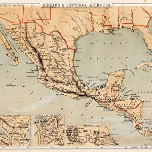
Premium Framed Print : Mexico and Central America map 1881


![]()
Framed Photos from Fine Art Storehouse
Mexico and Central America map 1881
Coltons Common School Geography 1881 New York Sheldon and Co
Unleash your creativity and transform your space into a visual masterpiece!
THEPALMER
Media ID 13669309
© This content is subject to copyright
Antilles Caribbean Central America Cuba Dominican Republic Globe Navigational Equipment Honduras Mexico Nicaragua Panama Paper Planet Earth Puerto Rico West Indies World Map
14"x18" Premium Frame
Contemporary style Premium Wooden Frame with 8"x12" Print. Complete with 2" White Mat and 1.25" thick MDF frame. Printed on 260 gsm premium paper. Glazed with shatter proof UV coated acrylic glass. Backing is paper covered backing with rubber bumpers. Supplied ready to hang with a pre-installed sawtooth/wire hanger. Care Instructions: Spot clean with a damp cloth. Securely packaged in a clear plastic bag and envelope in a reinforced cardboard shipper
FSC Real Wood Frame and Double Mounted with White Conservation Mountboard - Professionally Made and Ready to Hang
Estimated Image Size (if not cropped) is 30.4cm x 20.3cm (12" x 8")
Estimated Product Size is 45.8cm x 35.6cm (18" x 14")
These are individually made so all sizes are approximate
Artwork printed orientated as per the preview above, with landscape (horizontal) orientation to match the source image.
FEATURES IN THESE COLLECTIONS
> Fine Art Storehouse
> The Magical World of Illustration
> Palmer Illustrated Collection
> Fine Art Storehouse
> Map
> Historical Maps
> Fine Art Storehouse
> Map
> USA Maps
> North America
> United States of America
> New York
> Related Images
EDITORS COMMENTS
This print showcases a vintage map of Mexico and Central America from 1881. Taken from Colton's Common School Geography, published by Sheldon and Co in New York, this piece offers a glimpse into the past and the world as it was seen over a century ago. The map features intricate details of various countries including Honduras, Nicaragua, Panama, Cuba, Puerto Rico, Dominican Republic, and the West Indies. The Caribbean Sea is beautifully depicted alongside these landmasses. This horizontal image captures the essence of old-world cartography with its engraved illustrations and engravings. Printed on aged paper, this antique map exudes an air of nostalgia while also serving as a valuable resource for studying historical geography. It provides insight into how people perceived planet Earth during that time period. The inclusion of globe navigational equipment adds to the authenticity of this piece. Its presence reminds us of explorers who used such tools to navigate uncharted territories across oceans. Whether you are an enthusiast for physical geography or simply appreciate antique maps as works of art, this print by THEPALMER is sure to captivate your imagination. Hang it proudly in your home or office space to add a touch of history and wonder to any room.
MADE IN THE USA
Safe Shipping with 30 Day Money Back Guarantee
FREE PERSONALISATION*
We are proud to offer a range of customisation features including Personalised Captions, Color Filters and Picture Zoom Tools
SECURE PAYMENTS
We happily accept a wide range of payment options so you can pay for the things you need in the way that is most convenient for you
* Options may vary by product and licensing agreement. Zoomed Pictures can be adjusted in the Cart.