Premium Framed Print > Europe > France > Canton > Landes
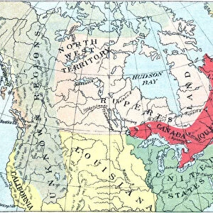
Premium Framed Print : Antique Map of North America at Canadas Confederation - 19th Century


![]()
Framed Photos from Fine Art Storehouse
Antique Map of North America at Canadas Confederation - 19th Century
Vintage map of the territories of North America at Canadian Confederation in 1867. Vintage etching circa late 19th century
Unleash your creativity and transform your space into a visual masterpiece!
powerofforever
Media ID 15149709
© This content is subject to copyright
14"x16" Premium Frame
Contemporary style Premium Wooden Frame with 8"x10" Print. Complete with 2" White Mat and 1.25" thick MDF frame. Printed on 260 gsm premium paper. Glazed with shatter proof UV coated acrylic glass. Backing is paper covered backing with rubber bumpers. Supplied ready to hang with a pre-installed sawtooth/wire hanger. Care Instructions: Spot clean with a damp cloth. Securely packaged in a clear plastic bag and envelope in a reinforced cardboard shipper
FSC Real Wood Frame and Double Mounted with White Conservation Mountboard - Professionally Made and Ready to Hang
Estimated Image Size (if not cropped) is 25.4cm x 20.3cm (10" x 8")
Estimated Product Size is 40.6cm x 35.6cm (16" x 14")
These are individually made so all sizes are approximate
Artwork printed orientated as per the preview above, with landscape (horizontal) orientation to match the source image.
FEATURES IN THESE COLLECTIONS
> Europe
> France
> Canton
> Landes
> Maps and Charts
> Related Images
> North America
> Canada
> Maps
> North America
> Canada
> Related Images
EDITORS COMMENTS
This print takes us back in time to the 19th century, offering a glimpse into the intricate details of an antique map. Titled "Antique Map of North America at Canada's Confederation" this vintage etching showcases the territories that comprised North America during the Canadian Confederation in 1867. The artist, powerofforever, has skillfully captured every contour and boundary line on this historical piece. As we delve into this mesmerizing artwork, our eyes are drawn to Ruppert's Land - a vast territory that once stretched across what is now known as Canada. The delicate lines and intricate markings depict not only geographical features but also hint at the political landscape of that era. Through this print, we can almost feel ourselves transported to a time when borders were being defined and nations were coming together. It serves as a reminder of how far we have come since then and how these early foundations shaped our present-day world. The attention to detail in this vintage map is truly remarkable; it invites us to explore each region with curiosity and wonder. Whether you're an avid history enthusiast or simply appreciate fine art, this exquisite print from Fine Art Storehouse will undoubtedly add depth and character to any space it graces.
MADE IN THE USA
Safe Shipping with 30 Day Money Back Guarantee
FREE PERSONALISATION*
We are proud to offer a range of customisation features including Personalised Captions, Color Filters and Picture Zoom Tools
SECURE PAYMENTS
We happily accept a wide range of payment options so you can pay for the things you need in the way that is most convenient for you
* Options may vary by product and licensing agreement. Zoomed Pictures can be adjusted in the Basket.