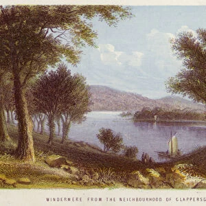
Premium Framed Print > Europe > United Kingdom > England > London > Boroughs > City of London
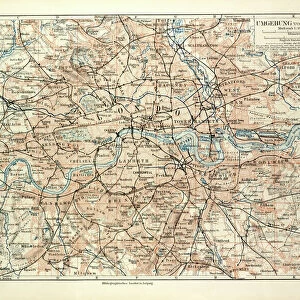
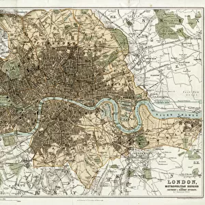
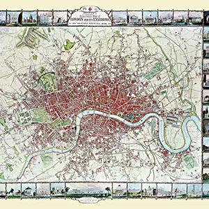
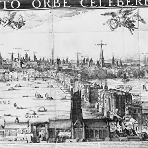
Premium Framed Print : City map of London, lithograph, lithograph, published in 1877


![]()
Framed Photos from Fine Art Storehouse
City map of London, lithograph, lithograph, published in 1877
City map of London, United Kingdom. Lithograph, published in 1877
Unleash your creativity and transform your space into a visual masterpiece!
Media ID 13666747
© ZU_09
78279 British Culture City Map City Of London City Street Contour Drawing Downtown District English Culture Image Date London England Stadtzentrum Thames River Topographic Map Topography Image Created 19th Century
14"x16" Premium Frame
Contemporary style Premium Wooden Frame with 8"x10" Print. Complete with 2" White Mat and 1.25" thick MDF frame. Printed on 260 gsm premium paper. Glazed with shatter proof UV coated acrylic glass. Backing is paper covered backing with rubber bumpers. Supplied ready to hang with a pre-installed sawtooth/wire hanger. Care Instructions: Spot clean with a damp cloth. Securely packaged in a clear plastic bag and envelope in a reinforced cardboard shipper
FSC Real Wood Frame and Double Mounted with White Conservation Mountboard - Professionally Made and Ready to Hang
Estimated Image Size (if not cropped) is 25.4cm x 20.3cm (10" x 8")
Estimated Product Size is 40.6cm x 35.6cm (16" x 14")
These are individually made so all sizes are approximate
Artwork printed orientated as per the preview above, with landscape (horizontal) orientation to match the source image.
FEATURES IN THESE COLLECTIONS
> Fine Art Storehouse
> Map
> Historical Maps
> Arts
> Contemporary art
> Photography
> Street art
> Arts
> Landscape paintings
> Waterfall and river artworks
> River artworks
> Arts
> Portraits
> Pop art gallery
> Street art portraits
> Europe
> United Kingdom
> England
> London
> Boroughs
> City of London
> Europe
> United Kingdom
> England
> London
> River Thames
> Europe
> United Kingdom
> England
> Maps
> Europe
> United Kingdom
> England
> Rivers
> Europe
> United Kingdom
> Maps
> Maps and Charts
> Early Maps
> Maps and Charts
> Related Images
EDITORS COMMENTS
This lithograph print of a city map showcases the grandeur and intricacy of London in 1877. A true testament to the artistry of cartography, this antique engraved image offers a glimpse into the topography and history of one of Europe's most iconic capitals. The horizontal composition allows for an immersive exploration of the city's downtown district, with every street and road meticulously depicted. The Thames River gracefully meanders through the heart of London, serving as a lifeline that has shaped its development over centuries. As we delve into this enchanting piece, we are transported back in time to witness English culture at its peak. The old-world charm emanating from each contour drawing evokes a sense of nostalgia for bygone eras. This image serves as a window into the past, offering us an opportunity to connect with ancient traditions and British heritage. With no people present in this snapshot frozen in time, our focus is solely on the architectural marvels that define London's skyline. From St Paul's Cathedral to Tower Bridge, these landmarks stand tall against a backdrop steeped in rich history. Whether you are an avid collector or simply captivated by historical artifacts, this lithograph print is sure to transport you back to 19th-century England - where tradition meets progress amidst cobblestone streets and bustling city life.
MADE IN THE USA
Safe Shipping with 30 Day Money Back Guarantee
FREE PERSONALISATION*
We are proud to offer a range of customisation features including Personalised Captions, Color Filters and Picture Zoom Tools
SECURE PAYMENTS
We happily accept a wide range of payment options so you can pay for the things you need in the way that is most convenient for you
* Options may vary by product and licensing agreement. Zoomed Pictures can be adjusted in the Cart.