Premium Framed Print > Europe > United Kingdom > England > Hampshire > Southampton
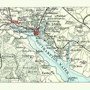
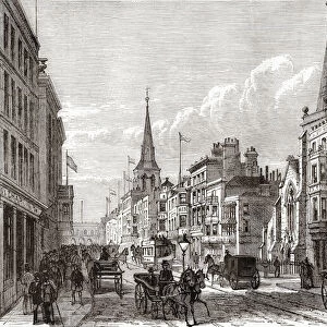
Premium Framed Print : Historical city map of Southampton, Hampshire, England, woodcut, published 1897


![]()
Framed Photos from Fine Art Storehouse
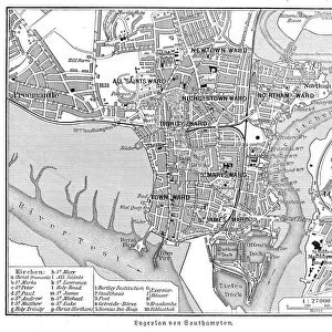
Historical city map of Southampton, Hampshire, England, woodcut, published 1897
Historical city map of Southampton, Hampshire, England. Wood engraving, published in 1897
Unleash your creativity and transform your space into a visual masterpiece!
ZU_09
Media ID 19859991
Hampshire England Southampton England
14"x16" Premium Frame
Contemporary style Premium Wooden Frame with 8"x10" Print. Complete with 2" White Mat and 1.25" thick MDF frame. Printed on 260 gsm premium paper. Glazed with shatter proof UV coated acrylic glass. Backing is paper covered backing with rubber bumpers. Supplied ready to hang with a pre-installed sawtooth/wire hanger. Care Instructions: Spot clean with a damp cloth. Securely packaged in a clear plastic bag and envelope in a reinforced cardboard shipper
FSC Real Wood Frame and Double Mounted with White Conservation Mountboard - Professionally Made and Ready to Hang
Estimated Image Size (if not cropped) is 25.4cm x 20.3cm (10" x 8")
Estimated Product Size is 40.6cm x 35.6cm (16" x 14")
These are individually made so all sizes are approximate
Artwork printed orientated as per the preview above, with landscape (horizontal) orientation to match the source image.
FEATURES IN THESE COLLECTIONS
> Fine Art Storehouse
> Map
> Historical Maps
> Europe
> United Kingdom
> England
> Hampshire
> Related Images
> Europe
> United Kingdom
> England
> Hampshire
> Southampton
> Europe
> United Kingdom
> England
> Maps
> Europe
> United Kingdom
> England
> Southampton
> Europe
> United Kingdom
> Maps
> Maps and Charts
> Early Maps
> Maps and Charts
> Related Images
EDITORS COMMENTS
This print showcases a historical city map of Southampton, Hampshire, England. Created through the meticulous art of woodcutting and published in 1897, this exquisite piece takes us on a journey back in time to explore the rich heritage of this enchanting city. Every intricate detail has been carefully etched into the wood engraving, capturing the essence of Southampton's past. As we gaze upon this remarkable artwork, we are transported to an era where horse-drawn carriages traversed cobblestone streets and grand Victorian architecture adorned every corner. The map reveals the layout of the city with precision, highlighting its bustling streets and iconic landmarks that have stood the test of time. From medieval walls to historic churches and renowned ports, each element tells a story steeped in history. This visual treasure not only serves as a testament to Southampton's vibrant past but also offers an opportunity for us to appreciate its evolution over centuries. The craftsmanship behind this wood engraving is truly awe-inspiring; it captures both the artistic skill involved and serves as a valuable historical document. Whether you are an avid collector or simply intrigued by local history, this print is sure to be a cherished addition to your collection – allowing you to immerse yourself in Southampton's captivating narrative whenever you desire.
MADE IN THE USA
Safe Shipping with 30 Day Money Back Guarantee
FREE PERSONALISATION*
We are proud to offer a range of customisation features including Personalised Captions, Color Filters and Picture Zoom Tools
SECURE PAYMENTS
We happily accept a wide range of payment options so you can pay for the things you need in the way that is most convenient for you
* Options may vary by product and licensing agreement. Zoomed Pictures can be adjusted in the Cart.