Premium Framed Print > Europe > Italy > Lazio > Rome
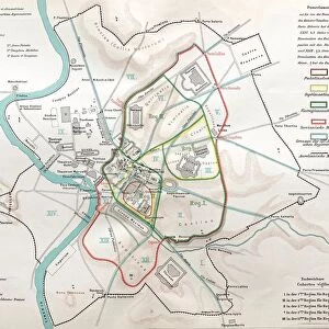
Premium Framed Print : Map of ancient Rome


![]()
Framed Photos from Fine Art Storehouse
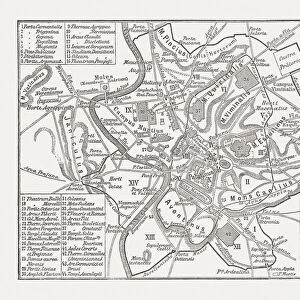
Map of ancient Rome
Illustration from 19th century
Unleash your creativity and transform your space into a visual masterpiece!
clu
Media ID 18298741
14"x16" Premium Frame
Contemporary style Premium Wooden Frame with 8"x10" Print. Complete with 2" White Mat and 1.25" thick MDF frame. Printed on 260 gsm premium paper. Glazed with shatter proof UV coated acrylic glass. Backing is paper covered backing with rubber bumpers. Supplied ready to hang with a pre-installed sawtooth/wire hanger. Care Instructions: Spot clean with a damp cloth. Securely packaged in a clear plastic bag and envelope in a reinforced cardboard shipper
FSC Real Wood Frame and Double Mounted with White Conservation Mountboard - Professionally Made and Ready to Hang
Estimated Image Size (if not cropped) is 25.4cm x 20.3cm (10" x 8")
Estimated Product Size is 40.6cm x 35.6cm (16" x 14")
These are individually made so all sizes are approximate
Artwork printed orientated as per the preview above, with landscape (horizontal) orientation to match the source image.
FEATURES IN THESE COLLECTIONS
> Fine Art Storehouse
> Map
> Historical Maps
> Europe
> Italy
> Lazio
> Rome
> Maps and Charts
> Early Maps
> Maps and Charts
> Related Images
EDITORS COMMENTS
This print showcases a mesmerizing "Map of ancient Rome" that takes us on a journey back in time to the illustrious days of the Roman Empire. Illustrated during the 19th century, this intricate artwork by clu is an exquisite depiction of one of history's most iconic cities. The map itself is a testament to the meticulous attention to detail and artistic skill employed by its creator. Every street, building, and landmark has been intricately drawn with precision, offering viewers an immersive experience into ancient Rome's grandeur. The vibrant colors used in this illustration bring life to each corner of the city, allowing us to visualize how it may have looked centuries ago. As we explore this historical masterpiece, our eyes are drawn towards notable landmarks such as the Colosseum, Pantheon, and Roman Forum. These architectural marvels stand proudly amidst bustling streets filled with chariots and pedestrians going about their daily lives. It is through these visual cues that we can truly appreciate the magnificence and scale of ancient Rome. Whether you are an art enthusiast or history buff, this print serves as both a visually stunning piece for your collection and an educational tool that transports you back in time. Displaying it within your home or office will undoubtedly spark conversations about one of civilization's greatest achievements - Ancient Rome!
MADE IN THE USA
Safe Shipping with 30 Day Money Back Guarantee
FREE PERSONALISATION*
We are proud to offer a range of customisation features including Personalised Captions, Color Filters and Picture Zoom Tools
SECURE PAYMENTS
We happily accept a wide range of payment options so you can pay for the things you need in the way that is most convenient for you
* Options may vary by product and licensing agreement. Zoomed Pictures can be adjusted in the Cart.