Premium Framed Print > South America > Bolivia > Maps
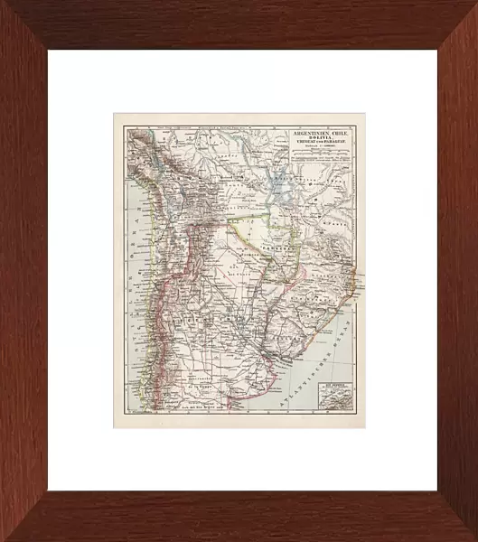
Premium Framed Print : Map of Argentine, Chile and Bolivia 1900


![]()
Framed Photos from Fine Art Storehouse
Map of Argentine, Chile and Bolivia 1900
Meyers hand-Atlas Leipzig und Wien Verlag des Bibliographischen Instituts 1900
Unleash your creativity and transform your space into a visual masterpiece!
THEPALMER
Media ID 18106895
© 2014 Roberto Adrian Photography
14"x16" Premium Frame
Contemporary style Premium Wooden Frame with 8"x10" Print. Complete with 2" White Mat and 1.25" thick MDF frame. Printed on 260 gsm premium paper. Glazed with shatter proof UV coated acrylic glass. Backing is paper covered backing with rubber bumpers. Supplied ready to hang with a pre-installed sawtooth/wire hanger. Care Instructions: Spot clean with a damp cloth. Securely packaged in a clear plastic bag and envelope in a reinforced cardboard shipper
FSC Real Wood Frame and Double Mounted with White Conservation Mountboard - Professionally Made and Ready to Hang
Estimated Image Size (if not cropped) is 20.3cm x 25.4cm (8" x 10")
Estimated Product Size is 35.6cm x 40.6cm (14" x 16")
These are individually made so all sizes are approximate
Artwork printed orientated as per the preview above, with portrait (vertical) orientation to match the source image.
FEATURES IN THESE COLLECTIONS
> Fine Art Storehouse
> Map
> Historical Maps
> South America
> Argentina
> Maps
> South America
> Argentina
> Related Images
> South America
> Bolivia
> Maps
> South America
> Bolivia
> Related Images
> South America
> Chile
> Maps
> South America
> Chile
> Related Images
EDITORS COMMENTS
In this print titled "Map of Argentine, Chile and Bolivia 1900" we are transported back in time to the early 20th century. The image showcases a beautifully detailed map from the renowned Meyers hand-Atlas Leipzig und Wien Verlag des Bibliographischen Instituts 1900. Created by THEPALMER, this print offers a glimpse into the rich history and geography of South America. The map itself is a testament to the meticulous craftsmanship of cartographers during that era. Every contour line, river system, and mountain range is intricately depicted with precision and accuracy. It serves as a visual representation of the vastness and diversity found within these three countries: Argentina, Chile, and Bolivia. As we examine this vintage piece closely, it becomes evident that it holds more than just geographical information; it tells stories of exploration, colonization, trade routes, and cultural exchange. It invites us to embark on an imaginary journey through time as we trace our fingers along its faded borders. This print not only appeals to history enthusiasts but also serves as a reminder of how maps have shaped our understanding of the world throughout centuries. It evokes feelings of nostalgia for simpler times when paper maps were cherished possessions used for navigation or simply admired for their beauty. "The Map of Argentine, Chile and Bolivia 1900" by THEPALMER is an exquisite piece that captures both artistry and historical significance in one frame—a true treasure for any admirer seeking to add depth to their collection or inf
MADE IN THE USA
Safe Shipping with 30 Day Money Back Guarantee
FREE PERSONALISATION*
We are proud to offer a range of customisation features including Personalised Captions, Color Filters and Picture Zoom Tools
SECURE PAYMENTS
We happily accept a wide range of payment options so you can pay for the things you need in the way that is most convenient for you
* Options may vary by product and licensing agreement. Zoomed Pictures can be adjusted in the Cart.