Premium Framed Print > Arts > Artists > M > Mexican School Mexican School
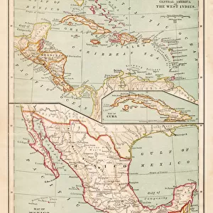
Premium Framed Print : Map of Mexico and Central America 1871


![]()
Framed Photos from Fine Art Storehouse
Map of Mexico and Central America 1871
Colton and Fitchs Introductory School Geography - New York: Sheldon and Company 1871
Unleash your creativity and transform your space into a visual masterpiece!
THEPALMER
Media ID 15256733
© This content is subject to copyright
Caribbean Central America Cuba Dominican Republic Honduras Mexico Nicaragua Panama Puerto Rico West Indies
14"x16" Premium Frame
Contemporary style Premium Wooden Frame with 8"x10" Print. Complete with 2" White Mat and 1.25" thick MDF frame. Printed on 260 gsm premium paper. Glazed with shatter proof UV coated acrylic glass. Backing is paper covered backing with rubber bumpers. Supplied ready to hang with a pre-installed sawtooth/wire hanger. Care Instructions: Spot clean with a damp cloth. Securely packaged in a clear plastic bag and envelope in a reinforced cardboard shipper
FSC Real Wood Frame and Double Mounted with White Conservation Mountboard - Professionally Made and Ready to Hang
Estimated Image Size (if not cropped) is 25.4cm x 20.3cm (10" x 8")
Estimated Product Size is 40.6cm x 35.6cm (16" x 14")
These are individually made so all sizes are approximate
Artwork printed orientated as per the preview above, with landscape (horizontal) orientation to match the source image.
FEATURES IN THESE COLLECTIONS
> Fine Art Storehouse
> Map
> Historical Maps
> Arts
> Artists
> M
> Mexican School Mexican School
> Maps and Charts
> Related Images
> North America
> Cuba
> Maps
> North America
> Cuba
> Related Images
> North America
> Dominican Republic
> Maps
> North America
> Dominican Republic
> Related Images
> North America
> Honduras
> Maps
> North America
> Honduras
> Related Images
> North America
> Mexico
> Related Images
EDITORS COMMENTS
In this print titled "Map of Mexico and Central America 1871" we are transported back in time to the late 19th century. The map, originally featured in Colton and Fitch's Introductory School Geography, offers a fascinating glimpse into the geopolitical landscape of that era. With intricate details and vibrant colors, the map showcases not only Mexico and Central America but also other significant regions such as Cuba, Puerto Rico, and the West Indies. It provides a comprehensive overview of countries like Honduras, Nicaragua, Panama, and the Dominican Republic with their borders clearly delineated. The craftsmanship evident in this print is remarkable; it captures both historical accuracy and artistic beauty. The delicate lines tracing coastlines, rivers snaking through vast territories, and mountains majestically rising from the land evoke a sense of wonder about these distant lands. As we gaze upon this piece by THEPALMER from Fine Art Storehouse, we can't help but reflect on how much has changed since 1871. This snapshot freezes time for us to appreciate an era when cartography was still being explored as a means to understand our world better. Whether you're an avid history enthusiast or simply captivated by vintage maps' allure, this print serves as a reminder of our ever-evolving planet's rich past.
MADE IN THE USA
Safe Shipping with 30 Day Money Back Guarantee
FREE PERSONALISATION*
We are proud to offer a range of customisation features including Personalised Captions, Color Filters and Picture Zoom Tools
SECURE PAYMENTS
We happily accept a wide range of payment options so you can pay for the things you need in the way that is most convenient for you
* Options may vary by product and licensing agreement. Zoomed Pictures can be adjusted in the Cart.