Premium Framed Print > Europe > France > Canton > Landes
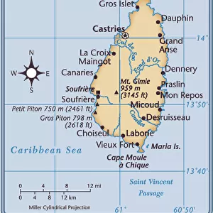
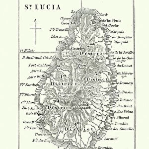
Premium Framed Print : Map of Saint Lucia, 19th Century


![]()
Framed Photos from Fine Art Storehouse
Map of Saint Lucia, 19th Century
Vintage engraving of Map of Saint Lucia, 19th Century
Unleash your creativity and transform your space into a visual masterpiece!
duncan1890
Media ID 15231355
© This content is subject to copyright
1870s Antilles Caribbean Equipment Ground Island Land Land Feature Lesser Antilles Natural Phenomenon Navigational Equipment Retro St Lucia Style Styles Supplies The Americas Victorian West Indies
14"x16" Premium Frame
Contemporary style Premium Wooden Frame with 8"x10" Print. Complete with 2" White Mat and 1.25" thick MDF frame. Printed on 260 gsm premium paper. Glazed with shatter proof UV coated acrylic glass. Backing is paper covered backing with rubber bumpers. Supplied ready to hang with a pre-installed sawtooth/wire hanger. Care Instructions: Spot clean with a damp cloth. Securely packaged in a clear plastic bag and envelope in a reinforced cardboard shipper
FSC Real Wood Frame and Double Mounted with White Conservation Mountboard - Professionally Made and Ready to Hang
Estimated Image Size (if not cropped) is 20.3cm x 25.4cm (8" x 10")
Estimated Product Size is 35.6cm x 40.6cm (14" x 16")
These are individually made so all sizes are approximate
Artwork printed orientated as per the preview above, with portrait (vertical) orientation to match the source image.
FEATURES IN THESE COLLECTIONS
> Fine Art Storehouse
> Map
> Historical Maps
> Europe
> France
> Canton
> Landes
> Historic
> Historical fashion trends
> Victorian fashion trends
> Historic
> Victorian era fashion
> Maps and Charts
> Related Images
> North America
> Saint Lucia
> Maps
> North America
> Saint Lucia
> Related Images
EDITORS COMMENTS
This vintage engraving of a 19th-century map of Saint Lucia takes us on a journey back in time. The intricate details and delicate lines tell the story of an island rich in history and natural beauty. As we gaze upon this black and white masterpiece, we are transported to an era where cartography was both artistry and science. The map showcases the enchanting Caribbean island nestled among the Lesser Antilles, capturing its unique land features with precision. It is a testament to the navigational equipment used during that period, as well as the craftsmanship involved in creating such detailed illustrations. In this print, we witness the fusion of old-fashioned style with Victorian elegance - a true reflection of 19th-century aesthetics. The woodcut technique adds depth and texture to each stroke, evoking a sense of nostalgia for times gone by. As we explore every inch of this antique treasure, our imagination runs wild with tales from St. Lucia's past. We can almost hear whispers from centuries ago echoing through its lush landscapes and crystal-clear waters. Duncan1890 has preserved not only a piece of history but also an exquisite work of art that captures the essence of Saint Lucia's allure. This print serves as a reminder that even in our modern world, there is still room for appreciation and admiration for the wonders crafted by human hands long ago.
MADE IN THE USA
Safe Shipping with 30 Day Money Back Guarantee
FREE PERSONALISATION*
We are proud to offer a range of customisation features including Personalised Captions, Color Filters and Picture Zoom Tools
SECURE PAYMENTS
We happily accept a wide range of payment options so you can pay for the things you need in the way that is most convenient for you
* Options may vary by product and licensing agreement. Zoomed Pictures can be adjusted in the Cart.