Premium Framed Print > Europe > Germany > Politics
Premium Framed Print : Political map of Europe, lithograph, published in 1893


![]()
Framed Photos from Fine Art Storehouse
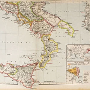
Political map of Europe, lithograph, published in 1893
Political map of Europe. Descriptions in German. Lithograph, published in 1893
Unleash your creativity and transform your space into a visual masterpiece!
ZU_09
Media ID 25197733
14"x16" Premium Frame
Contemporary style Premium Wooden Frame with 8"x10" Print. Complete with 2" White Mat and 1.25" thick MDF frame. Printed on 260 gsm premium paper. Glazed with shatter proof UV coated acrylic glass. Backing is paper covered backing with rubber bumpers. Supplied ready to hang with a pre-installed sawtooth/wire hanger. Care Instructions: Spot clean with a damp cloth. Securely packaged in a clear plastic bag and envelope in a reinforced cardboard shipper
FSC Real Wood Frame and Double Mounted with White Conservation Mountboard - Professionally Made and Ready to Hang
Estimated Image Size (if not cropped) is 25.4cm x 20.3cm (10" x 8")
Estimated Product Size is 40.6cm x 35.6cm (16" x 14")
These are individually made so all sizes are approximate
Artwork printed orientated as per the preview above, with landscape (horizontal) orientation to match the source image.
FEATURES IN THESE COLLECTIONS
> Fine Art Storehouse
> Map
> Historical Maps
> Maps and Charts
> Related Images
EDITORS COMMENTS
This lithograph, titled "Political map of Europe" takes us back to the year 1893, offering a glimpse into the geopolitical landscape of that era. The intricate details and meticulous craftsmanship showcased in this print are truly remarkable. With descriptions written in German, it not only serves as an artistic masterpiece but also as a historical artifact. As we delve into this visual representation of Europe's political boundaries from over a century ago, we can't help but marvel at how much has changed since then. This map invites us to explore the shifting alliances, territorial disputes, and power dynamics that shaped the continent during that time. The artist behind this lithograph remains unknown; however, their skillful execution is evident in every stroke and contour. Each country is meticulously outlined with precision and accuracy while vibrant colors differentiate them from one another. Beyond its aesthetic appeal lies a deeper narrative about European history. It reminds us of past conflicts and diplomatic negotiations that have influenced our present-day reality. From empires rising and falling to new nations emerging on the map, this artwork encapsulates an ever-evolving story etched onto paper. Whether you're an art enthusiast or a history buff, this print offers both beauty and knowledge within its borders. It serves as a testament to human curiosity and our desire to understand the world around us through visual representations like maps – snapshots frozen in time yet forever relevant.
MADE IN THE USA
Safe Shipping with 30 Day Money Back Guarantee
FREE PERSONALISATION*
We are proud to offer a range of customisation features including Personalised Captions, Color Filters and Picture Zoom Tools
SECURE PAYMENTS
We happily accept a wide range of payment options so you can pay for the things you need in the way that is most convenient for you
* Options may vary by product and licensing agreement. Zoomed Pictures can be adjusted in the Cart.