Premium Framed Print > Arts > Artists > O > Oceanic Oceanic
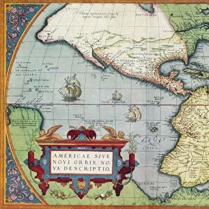
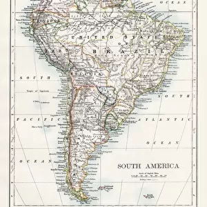
Premium Framed Print : South America Map Illustration, Travel, Exploration, Antique 1871 Illustration


![]()
Framed Photos from Fine Art Storehouse
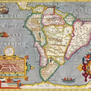
South America Map Illustration, Travel, Exploration, Antique 1871 Illustration
Color stock photo of an antique South America map illustration. Salvaged from an 1871 geography book
Unleash your creativity and transform your space into a visual masterpiece!
ideabug
Media ID 15387305
© ideabug
1870 1879 1871 Amazon Region Amazon River Atlantic Ocean Brazil Brown Chile Colombia Country Geographic Area Dirty Document Ecuador Education Exploration Geology Image Created 1870 1879 Latin American Culture Line Art Monoprint Pacific Ocean Page Paper Peru South America South American Culture Stained Topographic Map Topography Venezuela Green Color Image Created 19th Century
14"x16" Premium Frame
Contemporary style Premium Wooden Frame with 8"x10" Print. Complete with 2" White Mat and 1.25" thick MDF frame. Printed on 260 gsm premium paper. Glazed with shatter proof UV coated acrylic glass. Backing is paper covered backing with rubber bumpers. Supplied ready to hang with a pre-installed sawtooth/wire hanger. Care Instructions: Spot clean with a damp cloth. Securely packaged in a clear plastic bag and envelope in a reinforced cardboard shipper
FSC Real Wood Frame and Double Mounted with White Conservation Mountboard - Professionally Made and Ready to Hang
Estimated Image Size (if not cropped) is 20.3cm x 25.4cm (8" x 10")
Estimated Product Size is 35.6cm x 40.6cm (14" x 16")
These are individually made so all sizes are approximate
Artwork printed orientated as per the preview above, with portrait (vertical) orientation to match the source image.
FEATURES IN THESE COLLECTIONS
> Fine Art Storehouse
> Map
> Historical Maps
> Arts
> Artists
> O
> Oceanic Oceanic
> Maps and Charts
> Geological Map
> Maps and Charts
> Related Images
> South America
> Brazil
> Maps
> South America
> Brazil
> Related Images
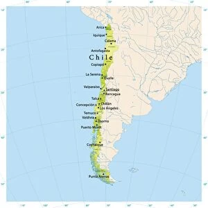
> South America
> Chile
> Maps
> South America
> Chile
> Related Images
> South America
> Colombia
> Maps
EDITORS COMMENTS
This print showcases an exquisite South America map illustration, evoking a sense of adventure and exploration. Salvaged from an 1871 geography book, this antique piece takes us back to the enchanting world of the 19th century. The color stock photo beautifully captures the intricate details of this engraved image, created with meticulous etching techniques. The map reveals the diverse topography and physical geography of South America, stretching from the Pacific Ocean to the Atlantic Ocean. It highlights countries like Venezuela, Peru, Colombia, Chile, Brazil, and Ecuador while featuring prominent landmarks such as the Amazon River and its lush rainforests. With its green hues and brown stains on aged paper, this vintage artwork exudes a certain charm that transports us to a bygone era. Its worn appearance adds character and authenticity to any space it graces. Beyond its aesthetic appeal lies a rich historical significance. This document serves as both an educational tool and a testament to past cultures in Latin America. It invites viewers to delve into history while igniting wanderlust for travel enthusiasts who yearn to explore these fascinating destinations firsthand. Whether displayed in homes or offices alike, this South America map illustration is sure to captivate admirers with its timeless beauty and cultural importance.
MADE IN THE USA
Safe Shipping with 30 Day Money Back Guarantee
FREE PERSONALISATION*
We are proud to offer a range of customisation features including Personalised Captions, Color Filters and Picture Zoom Tools
SECURE PAYMENTS
We happily accept a wide range of payment options so you can pay for the things you need in the way that is most convenient for you
* Options may vary by product and licensing agreement. Zoomed Pictures can be adjusted in the Cart.