Premium Framed Print > Arts > Artists > R > Roman Roman
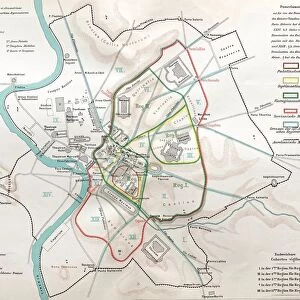
Premium Framed Print : Floor plan of Palatine Hill in Rome, published in 1878


![]()
Framed Photos from Fine Art Storehouse
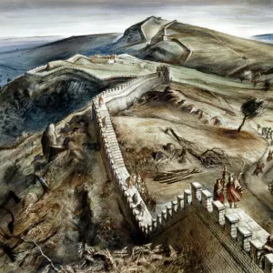
Floor plan of Palatine Hill in Rome, published in 1878
Floor plan of the archaeological remains of the Palatine Hill in Rome. The Palatine Hill (Latin: Mons Palatinus, Italian: Monte Palatino) is one of the seven hills of Rome and is the oldest inhabited part of the city. Already in the 10th century BC were found on the Palatine human settlements. Wood engraving, published in 1878
Unleash your creativity and transform your space into a visual masterpiece!
Media ID 13666875
© ZU_09
Ancient History Ancient Rome Blueprint Italian Culture Palate Plan Palatine Hill Roman Republic
14"x16" Premium Frame
Contemporary style Premium Wooden Frame with 8"x10" Print. Complete with 2" White Mat and 1.25" thick MDF frame. Printed on 260 gsm premium paper. Glazed with shatter proof UV coated acrylic glass. Backing is paper covered backing with rubber bumpers. Supplied ready to hang with a pre-installed sawtooth/wire hanger. Care Instructions: Spot clean with a damp cloth. Securely packaged in a clear plastic bag and envelope in a reinforced cardboard shipper
FSC Real Wood Frame and Double Mounted with White Conservation Mountboard - Professionally Made and Ready to Hang
Estimated Image Size (if not cropped) is 20.3cm x 25.4cm (8" x 10")
Estimated Product Size is 35.6cm x 40.6cm (14" x 16")
These are individually made so all sizes are approximate
Artwork printed orientated as per the preview above, with portrait (vertical) orientation to match the source image.
FEATURES IN THESE COLLECTIONS
> Fine Art Storehouse
> Map
> Historical Maps
> Fine Art Storehouse
> Map
> Italian Maps
> Arts
> Artists
> R
> Roman Roman
> Europe
> Italy
> Lazio
> Rome
> Historic
> Ancient civilizations
> Maps and Charts
> Early Maps
> Maps and Charts
> Italy
> Maps and Charts
> Related Images
EDITORS COMMENTS
This print showcases the floor plan of Palatine Hill in Rome, published in 1878. The intricate blueprint provides a glimpse into the archaeological remains of this historic site. Known as one of the seven hills of Rome, Palatine Hill holds immense significance as it is considered the oldest inhabited part of the city. Its rich history dates back to the 10th century BC when human settlements were discovered on its grounds. The wood engraving beautifully captures every detail, allowing us to explore and appreciate this ancient civilization's architectural marvels. This engraved image serves as a window into Italy's past, shedding light on its remarkable culture and heritage. The vertical composition emphasizes the grandeur and scale of these old ruins while highlighting their structural intricacies. As we delve into this meticulously crafted map, we are transported back in time, immersing ourselves in Roman Republic-era archaeology. With elements such as cartography and etching skillfully employed, this photograph offers an invaluable resource for historians and enthusiasts alike. It serves as a testament to our fascination with uncovering hidden stories from centuries gone by.
MADE IN THE USA
Safe Shipping with 30 Day Money Back Guarantee
FREE PERSONALISATION*
We are proud to offer a range of customisation features including Personalised Captions, Color Filters and Picture Zoom Tools
SECURE PAYMENTS
We happily accept a wide range of payment options so you can pay for the things you need in the way that is most convenient for you
* Options may vary by product and licensing agreement. Zoomed Pictures can be adjusted in the Cart.