Premium Framed Print > Europe > Austria > Maps
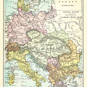
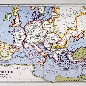
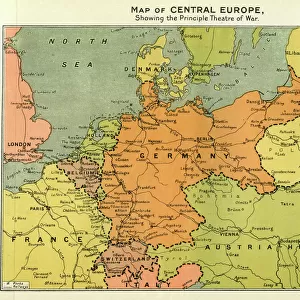
Premium Framed Print : Map of central Europe 1889


![]()
Framed Photos from Fine Art Storehouse
Map of central Europe 1889
Indiana Educational Series The Complete Geography - Indianapolis 1889
Unleash your creativity and transform your space into a visual masterpiece!
THEPALMER
Media ID 14756322
© This content is subject to copyright
Austria Denmark Norway Portugal Russia Sweden
14"x16" Premium Frame
Contemporary style Premium Wooden Frame with 8"x10" Print. Complete with 2" White Mat and 1.25" thick MDF frame. Printed on 260 gsm premium paper. Glazed with shatter proof UV coated acrylic glass. Backing is paper covered backing with rubber bumpers. Supplied ready to hang with a pre-installed sawtooth/wire hanger. Care Instructions: Spot clean with a damp cloth. Securely packaged in a clear plastic bag and envelope in a reinforced cardboard shipper
FSC Real Wood Frame and Double Mounted with White Conservation Mountboard - Professionally Made and Ready to Hang
Estimated Image Size (if not cropped) is 25.4cm x 20.3cm (10" x 8")
Estimated Product Size is 40.6cm x 35.6cm (16" x 14")
These are individually made so all sizes are approximate
Artwork printed orientated as per the preview above, with landscape (horizontal) orientation to match the source image.
FEATURES IN THESE COLLECTIONS
> Fine Art Storehouse
> Map
> Denmark Maps
> Fine Art Storehouse
> Map
> Historical Maps
> Fine Art Storehouse
> Map
> Italian Maps
> Europe
> Austria
> Related Images
> Europe
> Denmark
> Related Images
> Europe
> Germany
> Related Images
EDITORS COMMENTS
This print titled "Map of Central Europe 1889" takes us on a journey back in time to the late 19th century. The image showcases an authentic reproduction of a map from the Indiana Educational Series, specifically "The Complete Geography - Indianapolis 1889". With intricate details and vibrant colors, this piece offers a glimpse into the geographical landscape of central Europe during that era. As we delve into the composition, our eyes are immediately drawn to Portugal, Austria, Denmark, France, Germany, Italy, Norway, Russia, Spain and Sweden. Each country is meticulously outlined with delicate precision and labeled with elegant typography. This historical artifact not only serves as a visual representation of the region's boundaries but also provides valuable insights into political divisions and territorial claims at that time. "The Map of Central Europe 1889" by THEPALMER transports us to an age where cartography was both artistry and science. It invites us to appreciate how knowledge was disseminated through beautifully crafted maps like these. Whether displayed in a classroom or cherished within one's personal collection, this print evokes nostalgia for an era when exploration and discovery were paramount. With its rich historical significance and meticulous attention to detail captured by Fine Art Storehouse photographers' expertise; this artwork becomes more than just a decorative piece—it becomes a gateway to understanding our past while appreciating the beauty found within educational resources such as maps.
MADE IN THE USA
Safe Shipping with 30 Day Money Back Guarantee
FREE PERSONALISATION*
We are proud to offer a range of customisation features including Personalised Captions, Color Filters and Picture Zoom Tools
SECURE PAYMENTS
We happily accept a wide range of payment options so you can pay for the things you need in the way that is most convenient for you
* Options may vary by product and licensing agreement. Zoomed Pictures can be adjusted in the Cart.