Premium Framed Print > Europe > Italy > Lazio > Rome
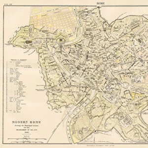
Premium Framed Print : Old map showing Rome arround 1st century BC


![]()
Framed Photos from Fine Art Storehouse
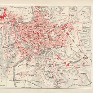
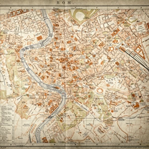
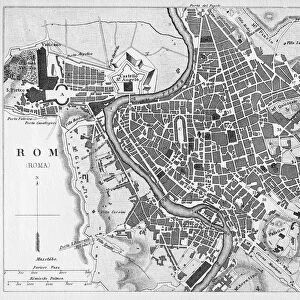
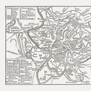
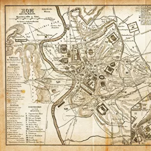
Old map showing Rome arround 1st century BC
Old map showing Rome circa 1st century bc
Original edition from my own archives
Source : Illustriertes Konversations Lexikon 1878
Unleash your creativity and transform your space into a visual masterpiece!
Grafissimo
Media ID 15372267
© This content is subject to copyright
Continent Direction Hemisphere Macro Mediterranean Sea Navigation Oceania Rome Topography World Map
14"x16" Premium Frame
Contemporary style Premium Wooden Frame with 8"x10" Print. Complete with 2" White Mat and 1.25" thick MDF frame. Printed on 260 gsm premium paper. Glazed with shatter proof UV coated acrylic glass. Backing is paper covered backing with rubber bumpers. Supplied ready to hang with a pre-installed sawtooth/wire hanger. Care Instructions: Spot clean with a damp cloth. Securely packaged in a clear plastic bag and envelope in a reinforced cardboard shipper
FSC Real Wood Frame and Double Mounted with White Conservation Mountboard - Professionally Made and Ready to Hang
Estimated Image Size (if not cropped) is 25.4cm x 20.3cm (10" x 8")
Estimated Product Size is 40.6cm x 35.6cm (16" x 14")
These are individually made so all sizes are approximate
Artwork printed orientated as per the preview above, with landscape (horizontal) orientation to match the source image.
FEATURES IN THESE COLLECTIONS
> Fine Art Storehouse
> Map
> Historical Maps
> Fine Art Storehouse
> Map
> Italian Maps
> Europe
> Italy
> Lazio
> Rome
> Maps and Charts
> Italy
> Maps and Charts
> Related Images
> Maps and Charts
> World
EDITORS COMMENTS
This print takes us back in time to the ancient city of Rome during the 1st century BC. A true treasure from my personal archives, this old map showcases the grandeur and complexity of one of history's greatest civilizations. With intricate details and precise cartography, this original edition from Illustriertes Konversations Lexikon 1878 offers a glimpse into the topography and layout of Rome at its peak. The Mediterranean Sea serves as a prominent feature, reminding us of Rome's strategic location as a hub for trade and conquest. As we explore this antique masterpiece, our eyes are drawn to the direction markers that guide travelers through various regions within Europe, Oceania, and even beyond. This horizontal world map reveals not only Rome's influence but also highlights other significant continents on Earth. The macro perspective allows us to appreciate how vast and interconnected our world was even centuries ago. It is fascinating to imagine navigating these lands without modern technology or transportation systems. Grafissimo has masterfully captured every detail in this photo print, preserving its historical significance for generations to come. Whether you are an enthusiast of ancient civilizations or simply intrigued by cartography, this piece will transport you back in time while igniting your curiosity about our rich past.
MADE IN THE USA
Safe Shipping with 30 Day Money Back Guarantee
FREE PERSONALISATION*
We are proud to offer a range of customisation features including Personalised Captions, Color Filters and Picture Zoom Tools
SECURE PAYMENTS
We happily accept a wide range of payment options so you can pay for the things you need in the way that is most convenient for you
* Options may vary by product and licensing agreement. Zoomed Pictures can be adjusted in the Cart.