Premium Framed Print > Maps and Charts > Americas
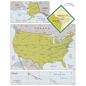
Premium Framed Print : Physical map of North America


![]()
Framed Photos from Fine Art Storehouse
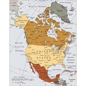
Physical map of North America
Vector illustration of the physical map of North America
Reference map was created by the US Central Intelligence Agency and is available as a public domain map at the University of Texas Libraries website
Unleash your creativity and transform your space into a visual masterpiece!
Media ID 15192866
16"x16" Premium Frame
Contemporary style Premium Wooden Frame with 10"x10" Print. Complete with 2" White Mat and 1.25" thick MDF frame. Printed on 260 gsm premium paper. Glazed with shatter proof UV coated acrylic glass. Backing is paper covered backing with rubber bumpers. Supplied ready to hang with a pre-installed sawtooth/wire hanger. Care Instructions: Spot clean with a damp cloth. Securely packaged in a clear plastic bag and envelope in a reinforced cardboard shipper
FSC Real Wood Frame and Double Mounted with White Conservation Mountboard - Professionally Made and Ready to Hang
Estimated Image Size (if not cropped) is 25.4cm x 25.4cm (10" x 10")
Estimated Product Size is 40.6cm x 40.6cm (16" x 16")
These are individually made so all sizes are approximate
Artwork printed orientated as per the preview above, with landscape (horizontal) or portrait (vertical) orientation to match the source image.
FEATURES IN THESE COLLECTIONS
> Fine Art Storehouse
> Map
> Reference Maps
> Maps and Charts
> Related Images
EDITORS COMMENTS
This print showcases a meticulously detailed physical map of North America, rendered in stunning vector illustration. A true masterpiece, this artwork is an accurate representation of the continent's diverse topography and geographical features. From the majestic Rocky Mountains to the vast Great Plains, every contour and elevation is intricately depicted with precision. Created by the US Central Intelligence Agency, this reference map has been made available as a public domain resource at the esteemed University of Texas Libraries website. Its inclusion in Fine Art Storehouse's collection highlights its significance not only as a valuable educational tool but also as a visually striking piece of art. The vibrant colors used in this print bring life to each region, allowing viewers to explore North America's natural wonders from the comfort of their own space. Whether it be tracing the meandering course of mighty rivers like the Mississippi or marveling at iconic landmarks such as Niagara Falls or Grand Canyon, this artwork offers an immersive experience that sparks curiosity about our planet's remarkable diversity. With its meticulous attention to detail and historical importance, this print serves as both an aesthetic delight and a valuable educational resource for geography enthusiasts and art connoisseurs alike. Displayed proudly on any wall, it invites viewers to embark on an imaginary journey across North America while appreciating its awe-inspiring beauty.
MADE IN THE USA
Safe Shipping with 30 Day Money Back Guarantee
FREE PERSONALISATION*
We are proud to offer a range of customisation features including Personalised Captions, Color Filters and Picture Zoom Tools
SECURE PAYMENTS
We happily accept a wide range of payment options so you can pay for the things you need in the way that is most convenient for you
* Options may vary by product and licensing agreement. Zoomed Pictures can be adjusted in the Cart.