Premium Framed Print > Europe > United Kingdom > England > Lincolnshire > Boston
Premium Framed Print : Boston Lincolnshire UK City Street Map


![]()
Framed Photos from Fine Art Storehouse
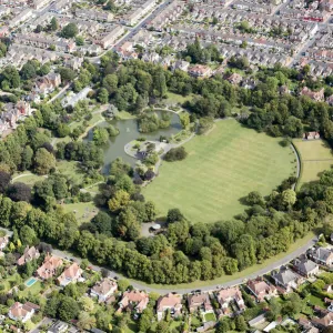
Boston Lincolnshire UK City Street Map
Vector Illustration of a City Street Map of Boston, Lincolnshire, UK. Included files are EPS (v10) and Hi-Res JPG
Unleash your creativity and transform your space into a visual masterpiece!
Frank Ramspott
Media ID 15055197
© Frank Ramspott, all rights reserved
Aerial View Boston Computer Graphic Directly Above Gray Green Lincolnshire Road Map Street Map Text Digitally Generated Image
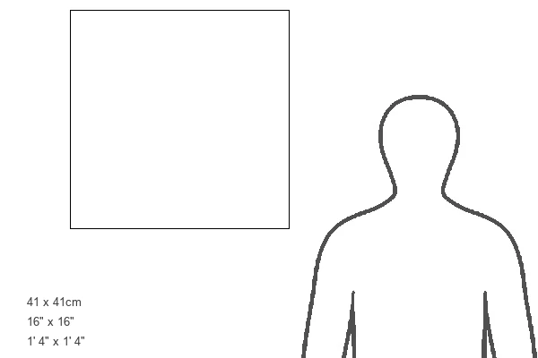
16"x16" Premium Frame
Contemporary style Premium Wooden Frame with 10"x10" Print. Complete with 2" White Mat and 1.25" thick MDF frame. Printed on 260 gsm premium paper. Glazed with shatter proof UV coated acrylic glass. Backing is paper covered backing with rubber bumpers. Supplied ready to hang with a pre-installed sawtooth/wire hanger. Care Instructions: Spot clean with a damp cloth. Securely packaged in a clear plastic bag and envelope in a reinforced cardboard shipper
FSC Real Wood Frame and Double Mounted with White Conservation Mountboard - Professionally Made and Ready to Hang
Estimated Image Size (if not cropped) is 25.4cm x 25.4cm (10" x 10")
Estimated Product Size is 40.6cm x 40.6cm (16" x 16")
These are individually made so all sizes are approximate
Artwork printed orientated as per the preview above, with landscape (horizontal) or portrait (vertical) orientation to match the source image.
FEATURES IN THESE COLLECTIONS
> Fine Art Storehouse
> Map
> Street Maps
> Aerial Photography
> Related Images
> Arts
> Contemporary art
> Digital artwork
> Street art
> Arts
> Landscape paintings
> Waterfall and river artworks
> River artworks
> Arts
> Portraits
> Pop art gallery
> Street art portraits
> Arts
> Street art graffiti
> Digital art
> Digital paintings
> Arts
> Street art graffiti
> Digital art
> Vector illustrations
> Europe
> United Kingdom
> England
> Lincolnshire
> Boston
> Europe
> United Kingdom
> England
> Lincolnshire
> Related Images
> Europe
> United Kingdom
> Maps
> Maps and Charts
> Related Images
EDITORS COMMENTS
This print showcases a meticulously detailed city street map of Boston, Lincolnshire in the United Kingdom. Created as a vector illustration by the talented artist Frank Ramspott, this artwork is both visually stunning and informative. The map encompasses various elements that make up the vibrant cityscape of Boston. From its charming streets to the meandering Witham River, every intricate detail has been beautifully captured in this digitally generated image. The roads and buildings are intricately depicted, offering a true-to-life representation of the town's layout. Rendered in shades of gray, green, blue, and white, this color image exudes an air of sophistication while maintaining clarity and precision. The aerial view from directly above adds depth to the composition and allows viewers to appreciate the entirety of Boston's physical geography. With no people present in the scene, all attention is directed towards exploring every nook and cranny on this remarkable map. Whether you are a cartography enthusiast or simply fascinated by urban landscapes, this print will undoubtedly captivate your imagination. Perfect for home decor or office spaces alike, this high-resolution JPG file can be easily printed or framed to adorn any wall with elegance. Discover new facets of Boston's charm each time you gaze upon this exceptional piece created by Frank Ramspott.
MADE IN THE USA
Safe Shipping with 30 Day Money Back Guarantee
FREE PERSONALISATION*
We are proud to offer a range of customisation features including Personalised Captions, Color Filters and Picture Zoom Tools
SECURE PAYMENTS
We happily accept a wide range of payment options so you can pay for the things you need in the way that is most convenient for you
* Options may vary by product and licensing agreement. Zoomed Pictures can be adjusted in the Cart.