Premium Framed Print > Arts > Still life artwork > Watercolor paintings > Fine art
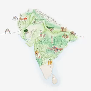
Premium Framed Print : Illustrated map of India showing ancient Mauryan empire


![]()
Framed Photos from Fine Art Storehouse
Illustrated map of India showing ancient Mauryan empire
Unleash your creativity and transform your space into a visual masterpiece!
Dorling Kindersley
Media ID 13540813
© This content is subject to copyright
Ancient Civilisations Background People Empire Geography Illustrated Map Incidental People India Mauryan Watercolour Painting
14"x16" Premium Frame
Contemporary style Premium Wooden Frame with 8"x10" Print. Complete with 2" White Mat and 1.25" thick MDF frame. Printed on 260 gsm premium paper. Glazed with shatter proof UV coated acrylic glass. Backing is paper covered backing with rubber bumpers. Supplied ready to hang with a pre-installed sawtooth/wire hanger. Care Instructions: Spot clean with a damp cloth. Securely packaged in a clear plastic bag and envelope in a reinforced cardboard shipper
FSC Real Wood Frame and Double Mounted with White Conservation Mountboard - Professionally Made and Ready to Hang
Estimated Image Size (if not cropped) is 25.4cm x 20.3cm (10" x 8")
Estimated Product Size is 40.6cm x 35.6cm (16" x 14")
These are individually made so all sizes are approximate
Artwork printed orientated as per the preview above, with landscape (horizontal) orientation to match the source image.
FEATURES IN THESE COLLECTIONS
> Fine Art Storehouse
> Photo Libraries
> Dorling Kindersley Prints
> Arts
> Still life artwork
> Watercolor paintings
> Fine art
> Arts
> Watercolor paintings
> Watercolor illustrations
> Asia
> India
> Related Images
> Historic
> Ancient civilizations
> Ancient India
> Historic
> Ancient civilizations
> Maps and Charts
> Early Maps
> Maps and Charts
> India
> Maps and Charts
> Related Images
EDITORS COMMENTS
This print showcases an exquisite "Illustrated map of India showing ancient Mauryan empire" by Dorling Kindersley. With a white background, the watercolor painting beautifully depicts the rich history and geography of this ancient civilization. The horizontal composition allows for a comprehensive view of the empire's vast territory. The intricate details in this artwork transport us back to a time when the Mauryan Empire flourished, offering a glimpse into one of India's most significant periods. As we explore the map, we can trace the contours of rivers and mountains that shaped their physical geography. Intriguingly, amidst this historical landscape, there are faint silhouettes of people in the background - perhaps representing ordinary citizens going about their daily lives during that era. This inclusion adds depth and realism to the illustration, making it feel alive with stories waiting to be discovered. Dorling Kindersley's masterful use of color brings vibrancy to every inch of this piece. The watercolor technique lends an ethereal quality to each stroke, enhancing our connection with both artistry and history. Whether you are an avid historian or simply appreciate fine art, this illustrated map is sure to captivate your imagination as you delve into India's ancient past. It serves as a reminder that even today, remnants from these remarkable civilizations continue to shape our understanding and appreciation for human achievements throughout time.
MADE IN THE USA
Safe Shipping with 30 Day Money Back Guarantee
FREE PERSONALISATION*
We are proud to offer a range of customisation features including Personalised Captions, Color Filters and Picture Zoom Tools
SECURE PAYMENTS
We happily accept a wide range of payment options so you can pay for the things you need in the way that is most convenient for you
* Options may vary by product and licensing agreement. Zoomed Pictures can be adjusted in the Cart.