Premium Framed Print > Arts > Still life artwork > Watercolor paintings > Fine art
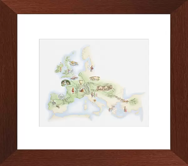
Premium Framed Print : Illustrated map of population of Celts across Iron Age Europe


![]()
Framed Photos from Fine Art Storehouse
Illustrated map of population of Celts across Iron Age Europe
Unleash your creativity and transform your space into a visual masterpiece!
Dorling Kindersley
Media ID 13540755
© This content is subject to copyright
Ancient Civilisations Ancient History Background People Celtic Celtic Style Geography Illustrated Map Incidental People Celt Iron Age Watercolour Painting
14"x16" Premium Frame
Contemporary style Premium Wooden Frame with 8"x10" Print. Complete with 2" White Mat and 1.25" thick MDF frame. Printed on 260 gsm premium paper. Glazed with shatter proof UV coated acrylic glass. Backing is paper covered backing with rubber bumpers. Supplied ready to hang with a pre-installed sawtooth/wire hanger. Care Instructions: Spot clean with a damp cloth. Securely packaged in a clear plastic bag and envelope in a reinforced cardboard shipper
FSC Real Wood Frame and Double Mounted with White Conservation Mountboard - Professionally Made and Ready to Hang
Estimated Image Size (if not cropped) is 25.4cm x 20.3cm (10" x 8")
Estimated Product Size is 40.6cm x 35.6cm (16" x 14")
These are individually made so all sizes are approximate
Artwork printed orientated as per the preview above, with landscape (horizontal) orientation to match the source image.
FEATURES IN THESE COLLECTIONS
> Fine Art Storehouse
> Photo Libraries
> Dorling Kindersley Prints
> Arts
> Still life artwork
> Watercolor paintings
> Fine art
> Arts
> Watercolor paintings
> Watercolor illustrations
> Europe
> Related Images
> Historic
> Ancient civilizations
> Maps and Charts
> Early Maps
> Maps and Charts
> Related Images
EDITORS COMMENTS
This print showcases an intricately detailed illustrated map of the population of Celts across Iron Age Europe. Created in a stunning watercolor painting style, this piece takes us back to ancient history and offers a glimpse into the rich Celtic civilization that once thrived on European soil. The map, set against a clean white background, allows for every intricate detail to shine through. The artist's skillful use of colors brings life to each region, highlighting the diverse territories inhabited by the Celts during this fascinating era. From Ireland and Britain to Gaul and Iberia, this horizontal composition provides a comprehensive view of their vast presence across the continent. As we delve into this ancient world depicted on paper, we are reminded of the importance of understanding our historical roots. This illustration serves as both an educational tool and a work of art that captures our imagination. Its meticulous craftsmanship invites us to explore not only physical geography but also cultural heritage. Whether you are an avid history enthusiast or simply appreciate beautiful artwork, this illustrated map is sure to captivate your attention. It transports us back in time while celebrating the legacy left behind by these ancient civilizations. Dorling Kindersley has masterfully created a visual masterpiece that will undoubtedly spark curiosity about our shared past.
MADE IN THE USA
Safe Shipping with 30 Day Money Back Guarantee
FREE PERSONALISATION*
We are proud to offer a range of customisation features including Personalised Captions, Color Filters and Picture Zoom Tools
SECURE PAYMENTS
We happily accept a wide range of payment options so you can pay for the things you need in the way that is most convenient for you
* Options may vary by product and licensing agreement. Zoomed Pictures can be adjusted in the Cart.