Premium Framed Print > Arts > Landscape paintings > Waterfall and river artworks > River artworks
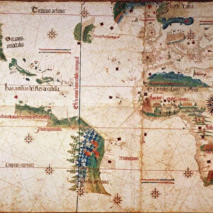
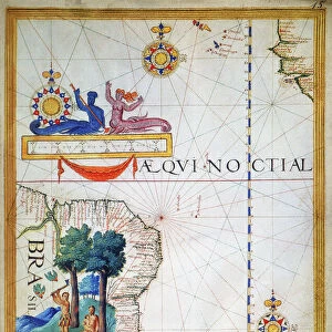
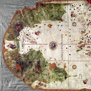
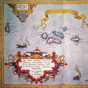
Premium Framed Print : PORTUGUESE MAP OF BRAZIL. Between the Amazon River and the Rio de la Plata, 1519


![]()
Framed Photos from Granger
PORTUGUESE MAP OF BRAZIL. Between the Amazon River and the Rio de la Plata, 1519
PORTUGUESE MAP OF BRAZIL.
Between the Amazon River and the Rio de la Plata, 1519
Granger holds millions of images spanning more than 25,000 years of world history, from before the Stone Age to the dawn of the Space Age
Media ID 12319650
1519 Age Of Discovery Amazon Amazon River Brazil Brazilian Jungle New World Portolan Chart Portuguese Rainforest Topography Tropical Rio De La Plata
14"x16" Premium Frame
Contemporary style Premium Wooden Frame with 8"x10" Print. Complete with 2" White Mat and 1.25" thick MDF frame. Printed on 260 gsm premium paper. Glazed with shatter proof UV coated acrylic glass. Backing is paper covered backing with rubber bumpers. Supplied ready to hang with a pre-installed sawtooth/wire hanger. Care Instructions: Spot clean with a damp cloth. Securely packaged in a clear plastic bag and envelope in a reinforced cardboard shipper
FSC Real Wood Frame and Double Mounted with White Conservation Mountboard - Professionally Made and Ready to Hang
Estimated Image Size (if not cropped) is 20.3cm x 25.4cm (8" x 10")
Estimated Product Size is 35.6cm x 40.6cm (14" x 16")
These are individually made so all sizes are approximate
Artwork printed orientated as per the preview above, with portrait (vertical) orientation to match the source image.
FEATURES IN THESE COLLECTIONS
> Granger Art on Demand
> Maps
> Arts
> Art Movements
> Renaissance Art
> Arts
> Landscape paintings
> Waterfall and river artworks
> River artworks
> Europe
> Portugal
> Related Images
> Maps and Charts
> Early Maps
> Maps and Charts
> Related Images
EDITORS COMMENTS
This print showcases a remarkable piece of history - the Portuguese Map of Brazil from 1519. In the age of discovery, this map was an invaluable tool that depicted the unexplored lands between the Amazon River and the Rio de la Plata. With its intricate details and meticulous craftsmanship, it offers a glimpse into early cartography during the Renaissance era. The map's significance lies in its portrayal of Brazil's topography, particularly highlighting the vastness of the Amazon rainforest and its mighty river. It transports us back to a time when these regions were shrouded in mystery and teeming with exotic wildlife. The dense jungle depicted on this chart evokes a sense of awe and wonder at nature's untamed beauty. As we study this historic artifact, we can't help but appreciate how it paved the way for future explorations and colonization efforts by European powers in South America. It serves as a testament to Portugal's ambition to expand its influence across new frontiers. This print is not just an artistic representation; it is also a tribute to those brave souls who ventured into unknown territories centuries ago. It reminds us of our connection to both past and present, as well as our responsibility towards preserving Earth's precious tropical ecosystems like the Amazon rainforest.
MADE IN THE USA
Safe Shipping with 30 Day Money Back Guarantee
FREE PERSONALISATION*
We are proud to offer a range of customisation features including Personalised Captions, Color Filters and Picture Zoom Tools
SECURE PAYMENTS
We happily accept a wide range of payment options so you can pay for the things you need in the way that is most convenient for you
* Options may vary by product and licensing agreement. Zoomed Pictures can be adjusted in the Cart.