Premium Framed Print > Arts > Artists > B > James Bayes
Premium Framed Print : Map of India in 1757, (c1912)
")

")


![]()
Framed Photos from Heritage Images
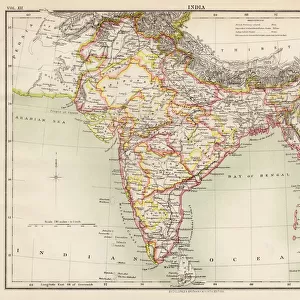
Map of India in 1757, (c1912)
Map of India in 1757, (c1912). From The Romance of India, edited by Herbert Strang. [Hodder & Stoughton, London, c1912]
Heritage Images features heritage image collections
Media ID 14978771
© The Print Collector
Arabian Sea Bay Of Bengal Charles James Lestrange English Text George Herbert Ely Herbert Herbert Strang Hodder Stoughton Hodder Stoughton Ltd Indian Ocean Romance Of India Strang Western Script Hindoostan
14"x16" Premium Frame
Contemporary style Premium Wooden Frame with 8"x10" Print. Complete with 2" White Mat and 1.25" thick MDF frame. Printed on 260 gsm premium paper. Glazed with shatter proof UV coated acrylic glass. Backing is paper covered backing with rubber bumpers. Supplied ready to hang with a pre-installed sawtooth/wire hanger. Care Instructions: Spot clean with a damp cloth. Securely packaged in a clear plastic bag and envelope in a reinforced cardboard shipper
FSC Real Wood Frame and Double Mounted with White Conservation Mountboard - Professionally Made and Ready to Hang
Estimated Image Size (if not cropped) is 20.3cm x 25.4cm (8" x 10")
Estimated Product Size is 35.6cm x 40.6cm (14" x 16")
These are individually made so all sizes are approximate
Artwork printed orientated as per the preview above, with portrait (vertical) orientation to match the source image.
FEATURES IN THESE COLLECTIONS
> Arts
> Artists
> B
> James Bayes
> Arts
> Artists
> C
> James Charles
> Arts
> Artists
> O
> Oceanic Oceanic
> Arts
> Artists
> W
> Charles White
> Arts
> Artists
> W
> George White
> Asia
> India
> Related Images
> Maps and Charts
> India
> Maps and Charts
> Related Images
EDITORS COMMENTS
This print showcases a historic "Map of India in 1757" that was published around 1912. Taken from the renowned book "The Romance of India" edited by Herbert Strang, this exquisite piece offers a glimpse into the rich cultural heritage and geographical expanse of the Indian subcontinent during the 18th century. The intricately detailed map highlights various regions, cities, rivers, and seas that played significant roles in shaping India's history. The Arabian Sea and Bay of Bengal flank either side of Hindoostan (as it was known then), reminding us of its strategic coastal position. Western script labels provide clarity to locations while adding an English touch to this historical artifact. Printed as an engraving on monochrome paper, this image captures the essence of a bygone era. It transports viewers back to a time when cartography served as both artistry and documentation. The fine craftsmanship is evident in every line etched onto the page. As we admire this remarkable print, we are reminded not only of India's vastness but also its literary contributions throughout centuries. This visual representation invites us to delve deeper into Indian literature, culture, and history – all encapsulated within one frame. Preserved with care by The Print Collector29 for future generations to appreciate, this snapshot serves as a testament to our enduring fascination with exploring different lands through maps – connecting us with our past while igniting curiosity about what lies beyond our own borders.
MADE IN THE USA
Safe Shipping with 30 Day Money Back Guarantee
FREE PERSONALISATION*
We are proud to offer a range of customisation features including Personalised Captions, Color Filters and Picture Zoom Tools
FREE COLORIZATION SERVICE
You can choose advanced AI Colorization for this picture at no extra charge!
SECURE PAYMENTS
We happily accept a wide range of payment options so you can pay for the things you need in the way that is most convenient for you
* Options may vary by product and licensing agreement. Zoomed Pictures can be adjusted in the Cart.