Premium Framed Print > Europe > United Kingdom > England > London > Boroughs > City of Westminster
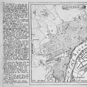
Premium Framed Print : Map of London, 1789 representing Elizabethan London


![]()
Framed Photos from Heritage Images
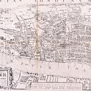
Map of London, 1789 representing Elizabethan London
View of the Cities of London and Westminster in the reign of Elizabeth I, 1558-1603
Heritage Images features heritage image collections
Media ID 15167954
© London Metropolitan Archives (City of London) / Heritage-Images
14"x18" Premium Frame
Contemporary style Premium Wooden Frame with 8"x12" Print. Complete with 2" White Mat and 1.25" thick MDF frame. Printed on 260 gsm premium paper. Glazed with shatter proof UV coated acrylic glass. Backing is paper covered backing with rubber bumpers. Supplied ready to hang with a pre-installed sawtooth/wire hanger. Care Instructions: Spot clean with a damp cloth. Securely packaged in a clear plastic bag and envelope in a reinforced cardboard shipper
FSC Real Wood Frame and Double Mounted with White Conservation Mountboard - Professionally Made and Ready to Hang
Estimated Image Size (if not cropped) is 30.4cm x 20.3cm (12" x 8")
Estimated Product Size is 45.8cm x 35.6cm (18" x 14")
These are individually made so all sizes are approximate
Artwork printed orientated as per the preview above, with landscape (horizontal) orientation to match the source image.
FEATURES IN THESE COLLECTIONS
> Arts
> Landscape paintings
> Waterfall and river artworks
> River artworks
> Europe
> United Kingdom
> England
> London
> Boroughs
> City of London
> Europe
> United Kingdom
> England
> London
> Boroughs
> City of Westminster
> Europe
> United Kingdom
> England
> London
> River Thames
> Europe
> United Kingdom
> England
> Maps
> Europe
> United Kingdom
> England
> Rivers
> Europe
> United Kingdom
> England
> Westminster
> Maps and Charts
> Related Images
EDITORS COMMENTS
This print showcases a historical treasure, the "Map of London, 1789 representing Elizabethan London". This exquisite engraving takes us back to the vibrant era of Queen Elizabeth I's reign from 1558 to 1603. The map offers an intricate view of both the City of London and Westminster during this significant period in English history. With its vivid colors and attention to detail, this anonymous masterpiece provides a glimpse into the bustling streets and landmarks that once adorned these iconic areas. The River Thames gracefully winds through the heart of the city, serving as a lifeline for trade and transportation. Displayed at Guildhall Library and Art Gallery, this sixteenth-century artifact is not only visually stunning but also serves as an invaluable geographical feature. It allows us to trace the evolution of London's landscape over time while capturing its Tudor charm. As we explore this remarkable piece, we are transported back in time when grand palaces stood proudly alongside humble dwellings. From St Paul's Cathedral to Tower Bridge, every street corner holds stories waiting to be discovered. This print is a testament to our rich heritage and reminds us of how far we have come as a society. It serves as a reminder that beneath modern skyscrapers lies centuries-old architecture steeped in tradition and history.
MADE IN THE USA
Safe Shipping with 30 Day Money Back Guarantee
FREE PERSONALISATION*
We are proud to offer a range of customisation features including Personalised Captions, Color Filters and Picture Zoom Tools
SECURE PAYMENTS
We happily accept a wide range of payment options so you can pay for the things you need in the way that is most convenient for you
* Options may vary by product and licensing agreement. Zoomed Pictures can be adjusted in the Cart.