Premium Framed Print > Europe > France > Maps
Premium Framed Print : Map of the Vikings & Western Christendom in the Ninth Century, (1935)
")
")


![]()
Framed Photos from Heritage Images
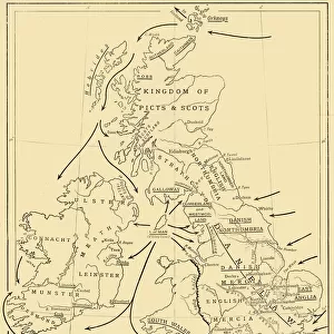
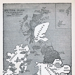
Map of the Vikings & Western Christendom in the Ninth Century, (1935)
Map of the Vikings & Western Christendom in the Ninth Century, (1935). Modern map showing territories occupied, controlled or raided by the Vikings (roughly 793-1066 AD). From A History of the Anglo-Saxons, Vol. II, by R. H. Hodgkin. [The Clarendon Press, Oxford, 1935]
Heritage Images features heritage image collections
Media ID 15466510
© The Print Collector / Heritage-Images
9th Century Anglo Saxon Colonisation Frank Frankish Invasion Scandinavia Territorial Territory Viking Vikings
14"x18" Premium Frame
Contemporary style Premium Wooden Frame with 8"x12" Print. Complete with 2" White Mat and 1.25" thick MDF frame. Printed on 260 gsm premium paper. Glazed with shatter proof UV coated acrylic glass. Backing is paper covered backing with rubber bumpers. Supplied ready to hang with a pre-installed sawtooth/wire hanger. Care Instructions: Spot clean with a damp cloth. Securely packaged in a clear plastic bag and envelope in a reinforced cardboard shipper
FSC Real Wood Frame and Double Mounted with White Conservation Mountboard - Professionally Made and Ready to Hang
Estimated Image Size (if not cropped) is 20.3cm x 30.4cm (8" x 12")
Estimated Product Size is 35.6cm x 45.8cm (14" x 18")
These are individually made so all sizes are approximate
Artwork printed orientated as per the preview above, with portrait (vertical) orientation to match the source image.
FEATURES IN THESE COLLECTIONS
> Maps and Charts
> Related Images
EDITORS COMMENTS
This print showcases a historical treasure, the "Map of the Vikings & Western Christendom in the Ninth Century" from 1935. A fusion of past and present, this modern map depicts the territories that were either occupied, controlled or raided by the Vikings between 793 and 1066 AD. Originally featured in R. H. Hodgkin's renowned book "A History of the Anglo-Saxons" this print offers a glimpse into an era marked by exploration and conflict. The vibrant colors bring to life the intricate web of Viking influence across Europe during this tumultuous period. From Scandinavia to Britain, France to Frankish lands, each country is meticulously outlined on this map as it was impacted by Viking invasions or colonization attempts. As we gaze upon this visual representation, we are reminded of how history shapes our present reality. The territorial boundaries depicted here reveal not only conquest but also cultural exchange between different peoples. This print serves as a testament to human resilience and adaptability amidst times of upheaval. Preserved through time with utmost care, this photograph allows us to appreciate both its artistic beauty and historical significance. It stands as a reminder that understanding our past is crucial for comprehending our present world - where we come from shapes who we are today.
MADE IN THE USA
Safe Shipping with 30 Day Money Back Guarantee
FREE PERSONALISATION*
We are proud to offer a range of customisation features including Personalised Captions, Color Filters and Picture Zoom Tools
SECURE PAYMENTS
We happily accept a wide range of payment options so you can pay for the things you need in the way that is most convenient for you
* Options may vary by product and licensing agreement. Zoomed Pictures can be adjusted in the Cart.