Premium Framed Print > Europe > France > Canton > Landes
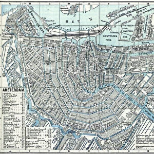
Premium Framed Print : 1835, S. D. U. K. City Map or Plan of Amsterdam, The Netherlands, topography, cartography


![]()
Framed Photos from Liszt Collection
1835, S. D. U. K. City Map or Plan of Amsterdam, The Netherlands, topography, cartography
1835, S.D.U.K. City Map or Plan of Amsterdam, The Netherlands
Liszt Collection of nineteenth-century engravings and images to browse and enjoy
Media ID 14005069
© Artokoloro Quint Lox Limited
1835 The Netherlands Antique Map Latitude Longitude Mappa Mundi Old Antique Plan Old Antique View Ols Antique Map Rare Old Maps Topo
14"x16" Premium Frame
Contemporary style Premium Wooden Frame with 8"x10" Print. Complete with 2" White Mat and 1.25" thick MDF frame. Printed on 260 gsm premium paper. Glazed with shatter proof UV coated acrylic glass. Backing is paper covered backing with rubber bumpers. Supplied ready to hang with a pre-installed sawtooth/wire hanger. Care Instructions: Spot clean with a damp cloth. Securely packaged in a clear plastic bag and envelope in a reinforced cardboard shipper
FSC Real Wood Frame and Double Mounted with White Conservation Mountboard - Professionally Made and Ready to Hang
Estimated Image Size (if not cropped) is 25.4cm x 20.3cm (10" x 8")
Estimated Product Size is 40.6cm x 35.6cm (16" x 14")
These are individually made so all sizes are approximate
Artwork printed orientated as per the preview above, with landscape (horizontal) orientation to match the source image.
FEATURES IN THESE COLLECTIONS
> Europe
> France
> Canton
> Landes
> Europe
> Netherlands
> Amsterdam
> Europe
> Netherlands
> Maps
> Europe
> Netherlands
> Posters
> Europe
> Netherlands
> Related Images
> Historic
> Space exploration
> Maps and Charts
> Early Maps
> Maps and Charts
> Netherlands
> Maps and Charts
> Related Images
> Maps and Charts
> World
EDITORS COMMENTS
This print showcases a remarkable piece of history - the 1835 S. D. U. K. City Map or Plan of Amsterdam, The Netherlands. Immerse yourself in the rich topography and cartography depicted in this vintage map, which offers a glimpse into the city's past. With its intricate details and precise illustrations, this map serves as both an artistic masterpiece and a valuable geographic resource. As you explore this ancient artifact, you'll be transported to a bygone era when navigation relied on paper maps like these. The grid lines, latitude and longitude markings, and geometric precision demonstrate the meticulous craftsmanship that went into creating such maps during that time. The faded colors and aged appearance add to its charm while reminding us of the passage of time. This decorative piece not only captures historical significance but also evokes a sense of wanderlust for those who appreciate travel and exploration. Whether you're an avid collector or simply fascinated by old maps, this rare gem from Liszt Collection is sure to captivate your imagination. Discover Amsterdam's past through this antique view as it takes you on a journey back in time to experience the city's geography like never before.
MADE IN THE USA
Safe Shipping with 30 Day Money Back Guarantee
FREE PERSONALISATION*
We are proud to offer a range of customisation features including Personalised Captions, Color Filters and Picture Zoom Tools
SECURE PAYMENTS
We happily accept a wide range of payment options so you can pay for the things you need in the way that is most convenient for you
* Options may vary by product and licensing agreement. Zoomed Pictures can be adjusted in the Cart.