Premium Framed Print > Europe > France > Canton > Landes
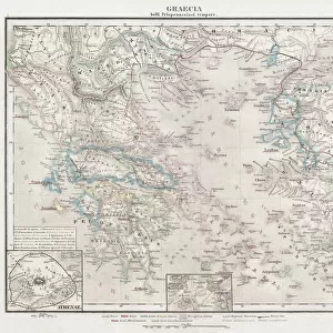
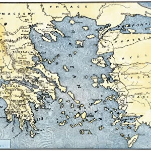
Premium Framed Print : 1865, Spruner Map of Greece, Macedonia and Thrace before the Peloponnesian War. topography


![]()
Framed Photos from Liszt Collection
1865, Spruner Map of Greece, Macedonia and Thrace before the Peloponnesian War. topography
1865, Spruner Map of Greece, Macedonia and Thrace before the Peloponnesian War
Liszt Collection of nineteenth-century engravings and images to browse and enjoy
Media ID 14006098
© Artokoloro Quint Lox Limited
Antique Map Latitude Longitude Mappa Mundi Old Antique Plan Old Antique View Ols Antique Map Rare Old Maps Topo
14"x16" Premium Frame
Contemporary style Premium Wooden Frame with 8"x10" Print. Complete with 2" White Mat and 1.25" thick MDF frame. Printed on 260 gsm premium paper. Glazed with shatter proof UV coated acrylic glass. Backing is paper covered backing with rubber bumpers. Supplied ready to hang with a pre-installed sawtooth/wire hanger. Care Instructions: Spot clean with a damp cloth. Securely packaged in a clear plastic bag and envelope in a reinforced cardboard shipper
FSC Real Wood Frame and Double Mounted with White Conservation Mountboard - Professionally Made and Ready to Hang
Estimated Image Size (if not cropped) is 25.4cm x 20.3cm (10" x 8")
Estimated Product Size is 40.6cm x 35.6cm (16" x 14")
These are individually made so all sizes are approximate
Artwork printed orientated as per the preview above, with landscape (horizontal) orientation to match the source image.
FEATURES IN THESE COLLECTIONS
> Europe
> France
> Canton
> Landes
> Europe
> Greece
> Related Images
> Europe
> Macedonia
> Posters
> Europe
> Macedonia
> Related Images
> Historic
> Ancient civilizations
> Ancient Greece
> Greek history
> Historic
> Space exploration
> Maps and Charts
> Early Maps
EDITORS COMMENTS
This vintage print takes us back to the year 1865, showcasing a Spruner Map of Greece, Macedonia, and Thrace before the Peloponnesian War. With its intricate topography and detailed cartography, this illustration offers a unique glimpse into the geographical landscape of ancient times. The map's grid system, featuring latitude and longitude lines, guides our eyes through the geometric representation of these historical regions. Its artistic rendering captures not only the landforms but also evokes a sense of exploration and discovery that characterized this era. Printed on aged paper with an antique touch, this piece exudes a rich historical charm. It serves as a reminder of how maps were once meticulously crafted by skilled artisans to aid navigation in uncharted territories. As we observe this rare old map from The Liszt Collection, we can't help but imagine the journeys taken by explorers who relied on such cartographic treasures. It invites us to delve into history and immerse ourselves in tales of civilizations long past. Whether you are an avid collector or simply appreciate artful depictions of our world's heritage, this decorative print is sure to captivate your imagination. Let it transport you back in time as you explore the fascinating region encompassing Greece, Macedonia, and Thrace before one of antiquity's most significant conflicts - The Peloponnesian War.
MADE IN THE USA
Safe Shipping with 30 Day Money Back Guarantee
FREE PERSONALISATION*
We are proud to offer a range of customisation features including Personalised Captions, Color Filters and Picture Zoom Tools
SECURE PAYMENTS
We happily accept a wide range of payment options so you can pay for the things you need in the way that is most convenient for you
* Options may vary by product and licensing agreement. Zoomed Pictures can be adjusted in the Cart.