Premium Framed Print > Europe > France > Paris > Maps
Premium Framed Print : France Administrative Political Map


![]()
Framed Photos from Map Marketing
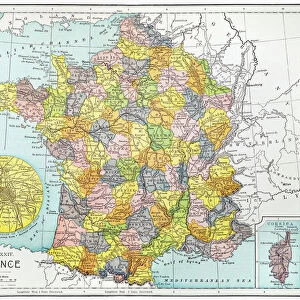
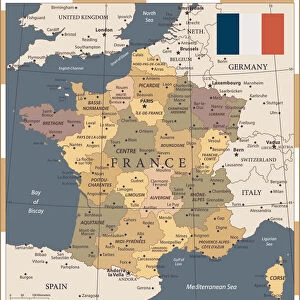
France Administrative Political Map
A detailed Administrative map of France showing the political administrative divisions of the country. Each Departement is coloured individually and numbered with the appropriate Numero de Departement and then grouped into the larger Regions. Within each Departement the constituent Cantons are also marked. Major cities and towns are shown and there are inserts showing Paris and its environs as well as Corsica and Franceaes dependent overseas territories
Media ID 19949231
© Map Marketing Ltd
Administrative Canton Counties
16"x16" Premium Frame
Contemporary style Premium Wooden Frame with 10"x10" Print. Complete with 2" White Mat and 1.25" thick MDF frame. Printed on 260 gsm premium paper. Glazed with shatter proof UV coated acrylic glass. Backing is paper covered backing with rubber bumpers. Supplied ready to hang with a pre-installed sawtooth/wire hanger. Care Instructions: Spot clean with a damp cloth. Securely packaged in a clear plastic bag and envelope in a reinforced cardboard shipper
FSC Real Wood Frame and Double Mounted with White Conservation Mountboard - Professionally Made and Ready to Hang
Estimated Image Size (if not cropped) is 25.4cm x 25.4cm (10" x 10")
Estimated Product Size is 40.6cm x 40.6cm (16" x 16")
These are individually made so all sizes are approximate
Artwork printed orientated as per the preview above, with landscape (horizontal) or portrait (vertical) orientation to match the source image.
FEATURES IN THESE COLLECTIONS
> Arts
> Photorealistic artworks
> Detailed art pieces
> Masterful detailing in art
> Europe
> France
> Canton
> Related Images
> Europe
> France
> Paris
> Maps
> Europe
> France
> Paris
> Politics
> Maps and Charts
> Popular Maps
> Maps and Charts
> Related Images
MADE IN THE USA
Safe Shipping with 30 Day Money Back Guarantee
FREE PERSONALISATION*
We are proud to offer a range of customisation features including Personalised Captions, Color Filters and Picture Zoom Tools
SECURE PAYMENTS
We happily accept a wide range of payment options so you can pay for the things you need in the way that is most convenient for you
* Options may vary by product and licensing agreement. Zoomed Pictures can be adjusted in the Cart.