Premium Framed Print > Maps and Charts > Related Images
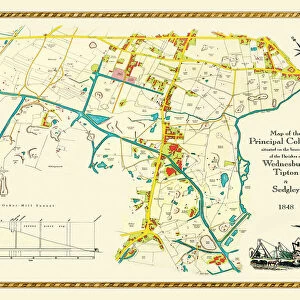
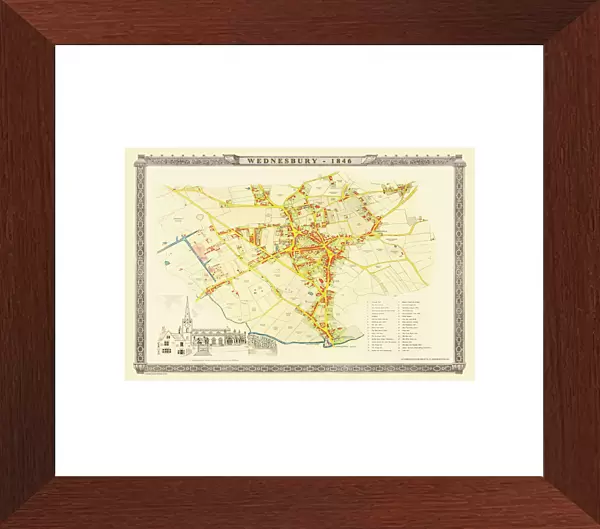
Premium Framed Print : Old Map of Wednesbury Town in the Black Country 1846


![]()
Framed Photos from MapSeeker
Old Map of Wednesbury Town in the Black Country 1846
J023
Welcome to the Mapseeker Image library and enter an historic gateway to one of the largest on-line collections of Historic Maps, Nostalgic Views, Vista's and Panorama's from a World gone by.
Media ID 20347088
Historic Map Old Town Plan Town Plan Wednesbury
14"x18" Premium Frame
Contemporary style Premium Wooden Frame with 8"x12" Print. Complete with 2" White Mat and 1.25" thick MDF frame. Printed on 260 gsm premium paper. Glazed with shatter proof UV coated acrylic glass. Backing is paper covered backing with rubber bumpers. Supplied ready to hang with a pre-installed sawtooth/wire hanger. Care Instructions: Spot clean with a damp cloth. Securely packaged in a clear plastic bag and envelope in a reinforced cardboard shipper
FSC Real Wood Frame and Double Mounted with White Conservation Mountboard - Professionally Made and Ready to Hang
Estimated Image Size (if not cropped) is 30.4cm x 20.3cm (12" x 8")
Estimated Product Size is 45.8cm x 35.6cm (18" x 14")
These are individually made so all sizes are approximate
Artwork printed orientated as per the preview above, with landscape (horizontal) orientation to match the source image.
FEATURES IN THESE COLLECTIONS
> MapSeeker
> British Town And City Plans
> English & Welsh PORTFOLIO
> Maps and Charts
> Related Images
EDITORS COMMENTS
This print showcases an exquisite piece of history, the "Old Map of Wednesbury Town in the Black Country 1846". Steeped in nostalgia and brimming with intricate details, this map takes us on a journey back to a bygone era. Dating back to 1846, this remarkable town plan offers a fascinating glimpse into Wednesbury's past. Every street, building, and landmark is meticulously depicted, allowing us to trace the evolution of this vibrant town nestled within the heart of England's Black Country. As we explore its winding roads and bustling market squares through this historic map, we are transported to a time when horse-drawn carriages roamed these streets. The craftsmanship evident in every stroke of ink reflects the dedication and skill that went into creating such detailed cartographic masterpieces during that period. This old map serves as both an invaluable historical artifact and a testament to human ingenuity. Whether you have personal ties to Wednesbury or simply appreciate the allure of vintage maps, this print is sure to captivate your imagination. Display it proudly in your home or office space as a conversation starter or use it as inspiration for further exploration into Wednesbury's rich heritage
MADE IN THE USA
Safe Shipping with 30 Day Money Back Guarantee
FREE PERSONALISATION*
We are proud to offer a range of customisation features including Personalised Captions, Color Filters and Picture Zoom Tools
SECURE PAYMENTS
We happily accept a wide range of payment options so you can pay for the things you need in the way that is most convenient for you
* Options may vary by product and licensing agreement. Zoomed Pictures can be adjusted in the Cart.