Premium Framed Print > Arts > Artists > T > John Tallis
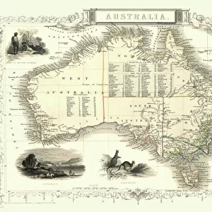
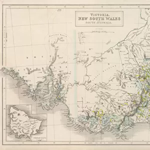
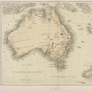
Premium Framed Print : New South Wales 1851


![]()
Framed Photos from MapSeeker
New South Wales 1851
A fine facimile artworked from an antique original map of New South Wales, Australia, issued as part of the 1851 edition of John Tallis and Companys " The Illustrated Atlas and Modern History of the World"
Welcome to the Mapseeker Image library and enter an historic gateway to one of the largest on-line collections of Historic Maps, Nostalgic Views, Vista's and Panorama's from a World gone by.
Media ID 20347503
© Mapseeker Publishing Ltd
John Tallis John Tallis Map Tallis Map
14"x18" Premium Frame
Contemporary style Premium Wooden Frame with 8"x12" Print. Complete with 2" White Mat and 1.25" thick MDF frame. Printed on 260 gsm premium paper. Glazed with shatter proof UV coated acrylic glass. Backing is paper covered backing with rubber bumpers. Supplied ready to hang with a pre-installed sawtooth/wire hanger. Care Instructions: Spot clean with a damp cloth. Securely packaged in a clear plastic bag and envelope in a reinforced cardboard shipper
FSC Real Wood Frame and Double Mounted with White Conservation Mountboard - Professionally Made and Ready to Hang
Estimated Image Size (if not cropped) is 20.3cm x 30.4cm (8" x 12")
Estimated Product Size is 35.6cm x 45.8cm (14" x 18")
These are individually made so all sizes are approximate
Artwork printed orientated as per the preview above, with portrait (vertical) orientation to match the source image.
FEATURES IN THESE COLLECTIONS
> MapSeeker
> Maps of Africa and Oceana
> Old Maps of Australia PORTFOLIO
> Arts
> Artists
> T
> John Tallis
> Europe
> United Kingdom
> Wales
> Maps
> Europe
> United Kingdom
> Wales
> Posters
> Europe
> United Kingdom
> Wales
> Related Images
> Maps and Charts
> Wales
> Maps and Charts
> World
EDITORS COMMENTS
This print showcases a remarkable piece of history - a fine facsimile artworked from an antique original map of New South Wales, Australia. This particular map was issued as part of the 1851 edition of John Tallis and Company's "The Illustrated Atlas and Modern History of the World". With its intricate details and exquisite craftsmanship, this old map transports us back to a bygone era when cartography was both an art form and a scientific endeavor. The delicate lines trace the contours of New South Wales, revealing its vast landscapes, rivers, mountains, and settlements. As we gaze upon this vintage treasure, we are reminded of the rich heritage that shaped Australia's development. It serves as a testament to the explorers who traversed unknown territories in search of new frontiers. The names etched on this map evoke stories untold - tales of pioneers who braved harsh conditions to establish thriving communities. John Tallis' expertise in creating visually stunning maps is evident in every brushstroke. His collaboration with John Rapkin brings forth not only geographical accuracy but also an aesthetic appeal that captivates our imagination. Whether you have ties to New South Wales or simply appreciate historical artifacts, this print offers a glimpse into Australia's past like no other. Display it proudly on your wall or gift it to someone who cherishes nostalgia and exploration. Let this old Australian map transport you back in time while celebrating the enduring beauty found within cartographic masterpieces such as these.
MADE IN THE USA
Safe Shipping with 30 Day Money Back Guarantee
FREE PERSONALISATION*
We are proud to offer a range of customisation features including Personalised Captions, Color Filters and Picture Zoom Tools
SECURE PAYMENTS
We happily accept a wide range of payment options so you can pay for the things you need in the way that is most convenient for you
* Options may vary by product and licensing agreement. Zoomed Pictures can be adjusted in the Cart.